


A Tropical Storm Warning is in effect for… * Northwestern Bahamas excluding Andros Island
A Tropical Storm Warning means that tropical storm conditions are expected somewhere within the warning area within 36 hours.
Interests along the east coast of Florida should monitor the progress of this system. For storm information specific to your area, please monitor products issued by your national meteorological service.
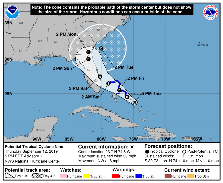
At 500 PM EDT (2100 UTC), the disturbance was centered near latitude 23.7 North, longitude 74.8 West. The system is expected to move toward the northwest near 8 mph (13 km/h), and this motion is forecast to continue during the next 2 days. On this track, the system is anticipated to move across the northwestern Bahamas on Friday, and along or over the east coast of central Florida on Saturday.
Maximum sustained winds are near 30 mph (45 km/h) with higher gusts. The disturbance is forecast to become tropical depression or a tropical storm during the next day or so.
Environmental conditions are favorable for a tropical depression or tropical storm to form within the next day or two.
* Formation chance through 48 hours…high…70 percent
* Formation chance through 5 days…high…80 percent
The estimated minimum central pressure is 1008 mb (29.77 inches).
Key Messages:
1. The disturbance is expected to become a tropical storm and bring tropical storm force winds to portions of the northwest Bahamas within 36 hours. As a result, advisories have been initiated on Potential Tropical Cyclone Nine. Note that forecast uncertainty for these disturbances is generally larger than for tropical cyclones, especially beyond 48-72 hours.
2. The system is expected to bring tropical-storm-force winds and heavy rainfall to portions of the northwest Bahamas on Friday and Saturday. Significant storm surge is not expected in the northwest Bahamas from this system. Residents there should follow any advice given by local officials.
3. The system could bring tropical-storm-force winds and rainfall to portions of the Florida east coast over the weekend. Residents there should monitor the progress of this system.
SCHOOLS ARE STILL OPEN FRIDAY AS WE ARE NOT EXPECTED TO RECEIVE TROPICAL STORM FORCE WINDS IN THE NEXT 24 HOURS.


