


The tropical cyclone’s cloud pattern became a little better organized overnight, with convective banding features becoming more evident over the western and southwestern portions of the circulation. Upper-level outflow is well-defined to the west of the system, and restricted over the eastern semicircle. The current intensity is set at 35 kt in agreement with Dvorak estimates from SAB and TAFB, and just slightly above the maximum winds from an earlier scatterometer pass, making the cyclone a tropical storm. Elsa is the earliest-known fifth named storm on record for the Atlantic basin in the satellite era (1966-present), breaking the record formerly held by Edouard on July 6, 2020.
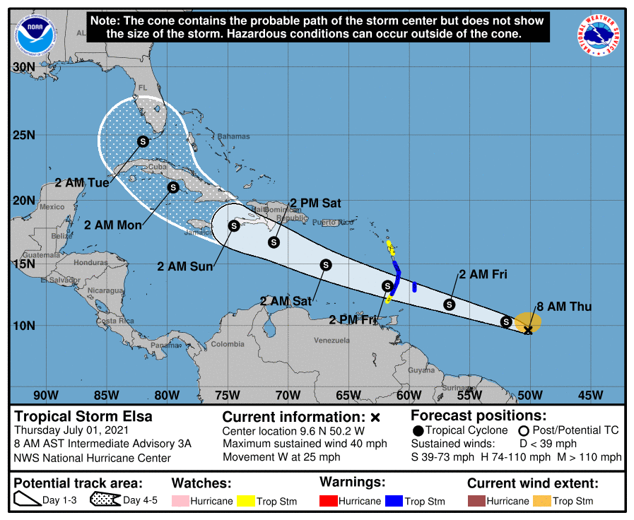
The storm has been accelerating westward overnight, and the initial motion is around 275/22 kt. A strong subtropical ridge is situated to the north of the storm, and this feature should steer the system quickly to the west-northwest for the next 3 days or so. There is
significant uncertainty in the track forecast from days 3-5. The ECMWF model turns the cyclone northward after interacting with Hispaniola while the other models such as the GFS, HWRF, and U.K. Met take Elsa across western Cuba and into the southeastern Gulf of
Mexico. The official forecast is similar to the previous one, and within the latter suite of guidance. However the discrepancy in the models makes confidence in this track lower than usual.
Some intensification is likely for the next day or two, since Elsa is expected to be in an environment of warm sea-surface temperatures, fairly low vertical wind shear, and high
mid-level relative humidity. However, the fast forward motion could result in some decoupling of the low- and higher-level circulation which would limit strengthening. Also, the potential interaction of the storm with the mountainous land masses of the Greater
Antilles later in the forecast period could disrupt the circulation somewhat. Therefore the official intensity forecast, like the previous one, is quite conservative and on the lower end of the guidance suite.
Key Messages:
1. Tropical storm conditions are expected beginning early Friday in portions of the Windward and southern Leeward Islands.
2. Heavy rainfall from the system will move quickly across the Windward and southern Leeward Islands, including Barbados, on Friday. Isolated flash flooding and mudslides are possible.
3. There is a risk of wind and rainfall impacts in portions of the Virgin Islands, Puerto Rico, Hispaniola, Cuba, the Turks and Caicos and the southeastern Bahamas through early next week. Interests in these areas should monitor the system’s progress and updates to the
forecast.
4. Interests in Florida should monitor updates to the forecast for this system, but it is too soon to determine what if any impacts could occur there next week given the uncertainty in the long-range forecast.
– Source: National Hurricane Center


