

The National Weather Service has issued a GALE WARNING for Saturday morning from 1 am to 1pm:
…GALE WARNING IN EFFECT FROM 1 AM TO 1 PM EST SATURDAY…
WHAT…Northwest winds 20 to 30 kt with gusts up to 40 kt and seas 7 to 10 ft possible.

WHERE…Portions of Gulf of Mexico, Biscayne Bay, Atlantic and Lake Okeechobee.
WHEN…From Friday evening through Saturday evening.
IMPACTS…Strong winds can cause hazardous seas which could capsize or damage vessels and reduce visibility.
PRECAUTIONARY/PREPAREDNESS ACTIONS…
A Gale Warning means winds of 34 to 47 knots are imminent or occurring. Operating a vessel in gale conditions requires experience and properly equipped vessels. It is highly recommended that mariners without the proper experience seek safe harbor prior to the onset of gale conditions.
COLD FRONT
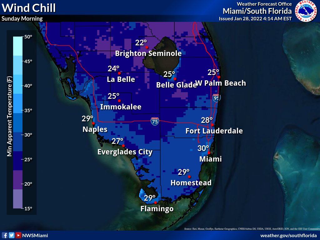
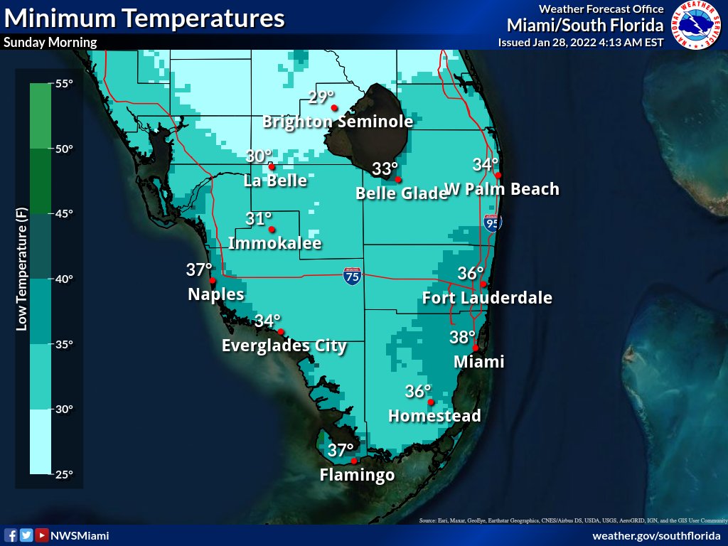
The National Weather Service also remind us that “A strong cold front will move through the region tonight with a few showers. Temperatures will plummet with some of the coldest air in about a decade moving into South Florida. A wind chill watch and a freeze watch have been issued for Sunday morning.”
WILL IT SNOW?
No kids. It won’t snow this weekend. The chance of precipitation stands at 1% Saturday and 0% Sunday.
Hazardous Weather Outlook for South Florida:
National Weather Service Miami FL
753 AM EST Fri Jan 28 2022
Coastal waters from Deerfield Beach to Ocean Reef FL out 20 NM-
Waters from Deerfield Beach to Ocean Reef FL from 20 to 60 NM
Inland Broward-Metro Broward-Inland Miami-Dade-Metro Miami-Dade-
Mainland Monroe-Coastal Palm Beach-Coastal Broward-Coastal Miami-
Dade-Far South Miami-Dade-
753 AM EST Fri Jan 28 2022
…Dense Fog Advisory Until 9 AM EST Eastern Areas Of South Florida…
…Freeze Watch/Wind Chill Watch For Northern Interior Areas Saturday Night…
…High Risk Of Rip Currents Collier County Beaches…
This hazardous weather outlook is for South Florida.
.DAY ONE…TODAY AND TONIGHT
Visibility: Patchy to areas of dense fog will be possible eastern areas of South Florida through early this morning. Visibilities down to one quarter of a mile or less is possible in the fog at times.
Rip Currents: A high risk for rip currents will be realized along the coast of Collier County by early Saturday morning.
Marine: Hazardous marine conditions will materialize ahead of a strong cold front, as a gale warning is in effect across the local waters by early Saturday morning. Enhanced wave activity to around 8 ft will be possible overnight tonight as winds sharply increase ahead
of the system.
.DAYS TWO THROUGH SEVEN…SATURDAY THROUGH THURSDAY
Very cold weather is expected this weekend, with low temperatures dropping below freezing across the interior on Saturday night. Wind chills could dip into the upper 20s across a large portion of the interior. Frost will also be a concern, especially Sunday night.
Marine conditions will continue to deteriorate quickly behind a strong cold front Friday night, and thus hazardous marine conditions will continue through the weekend. Enhanced swell and breezy winds will likely result in a high risk for rip currents across all beaches
this weekend.
Relative humidity values will drop below 35% Saturday, Sunday, and possibly Monday across portions of the interior which may lead to enhanced fire weather conditions. However, critical wind thresholds are not expected to be met (although it will be close on Saturday).


