

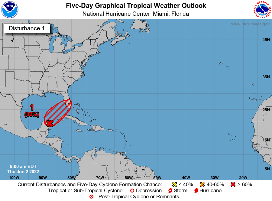
The National Hurricane Center believes the Low Pressure System over the Yucatan will strengthen into a Tropical Depression within the next 48 hours. It also has a chance of strengthening into a Tropical Storm. As such, the Hurricane Center may issue Tropical Storm Watches later today. The Hurricane Center believes the weather impact may be felt in South Florida late Friday. Please continue to monitor the storm as it approaches.
Hurricane Tax Holiday
Now through June 10th, take advantage of the Tax Free Holiday to purchase key disaster preparedness items tax free. These items include:
- $1,000 or less
- Portable generators used to provide light or communications or to preserve food in a power outage
- $100 or less
- Tarpaulins or other flexible waterproof sheeting
- Ground anchor systems
- Portable pet kennels
- $70 or less
- Smoke detectors or smoke alarms
- Fire extinguishers
- Carbon monoxide detectors
- $60 or less
- Nonelectric food storage coolers
- Portable power banks
- $50 or less
- Portable self-powered radios, two-way radios, or weather-band radios
- Gas or diesel fuel tanks
- Batteries, including rechargeable batteries, listed sizes only:
- AA-cell
- AAA-cell
- C-cell
- D-cell
- 6-volt
- 9-volt
- $40 or less
- Portable self-powered light sources
- Pet beds
- $30 or less
- Bags of dry pet food weighing 15 or fewer pounds
- $20 or less
- • Reusable ice
- Leashes, collars, and muzzles for pets
- Pet pads
- $15 or less
- Manual can openers
- Collapsible or travel-sized food or water bowls for pets
- Cat litter pans
- Pet waste disposal bags
- Hamster or rabbit substrate
- $2 or less
- Cans or pouches of wet pet food

Tropical Weather Outlook
NWS National Hurricane Center Miami FL
800 AM EDT Thu Jun 2 2022

For the North Atlantic…Caribbean Sea and the Gulf of Mexico:
1. Near the Yucatan Peninsula and Southeastern Gulf of Mexico:
A broad area of low pressure located over the northeastern portion of the Yucatan Peninsula continues to produce a large area of disorganized showers and thunderstorms over the northwestern Caribbean Sea and Yucatan Peninsula. Despite strong upper-level winds, this system is likely to become a tropical depression or tropical storm while it moves slowly northeastward over the northwestern Caribbean Sea and southeastern Gulf of Mexico during the next day or two. Interests in western Cuba, the Florida Keys, and the Florida Peninsula should monitor the progress of this system, and tropical storm watches or warnings could be required for some of these areas later today.
Regardless of development, areas of heavy rainfall are likely across portions of the Yucatan Peninsula and western Cuba during the next day or so, spreading across southern and central Florida and the Florida Keys Friday and Friday night, and the northwestern Bahamas on Saturday. These heavy rains could cause scattered to numerous flash floods across South Florida and the Florida Keys.
* Formation chance through 48 hours…high…80 percent.
* Formation chance through 5 days…high…80 percent.


