

UPDATE: We are now under a Tropical Storm Warning.
Nearly half of the State of Florida is under a Tropical Storm Warning. We have 100% chance of rain today.
KEY MESSAGES:

1. Heavy rain associated with the system is expected across western Cuba, where life-threatening flash flooding and mudslides are possible.
2. Heavy rain will affect portions of Central Florida, South Florida, and the Florida Keys today and continue through Saturday. Considerable flash and urban flooding is possible across South Florida and in the Keys. Flash and urban flooding is also possible across the northwestern Bahamas.
3. Tropical storm conditions are expected in the warning area in western Cuba today and tonight, in Florida tonight and on Saturday, and in the northwestern Bahamas on Saturday. Tropical storm conditions are also possible in the watch area in western Cuba today and tonight.
WATCHES AND WARNINGS
——————–
SUMMARY OF WATCHES AND WARNINGS IN EFFECT:
A Tropical Storm Warning is in effect for…
* Florida Keys including the Dry Tortugas
* Florida Bay
* West coast of Florida south of the Middle of Longboat Key to Card Sound Bridge
* East coast of Florida south of the Volusia/Brevard County Line to Card Sound Bridge
* Lake Okeechobee
* Cuban provinces of Pinar del Rio, Artemisa, La Habana, and Mayabeque
* Northwestern Bahamas
A Tropical Storm Watch is in effect for…
* Cuban provinces of Matanzas and the Isle of Youth
A Tropical Storm Warning means that tropical storm conditions are expected somewhere within the warning area within 36 hours.
A Tropical Storm Watch means that tropical storm conditions are possible somewhere within the watch area within 48 hours.
Interests elsewhere in the Florida Peninsula should monitor the progress of this system.
DISCUSSION AND OUTLOOK
———————-
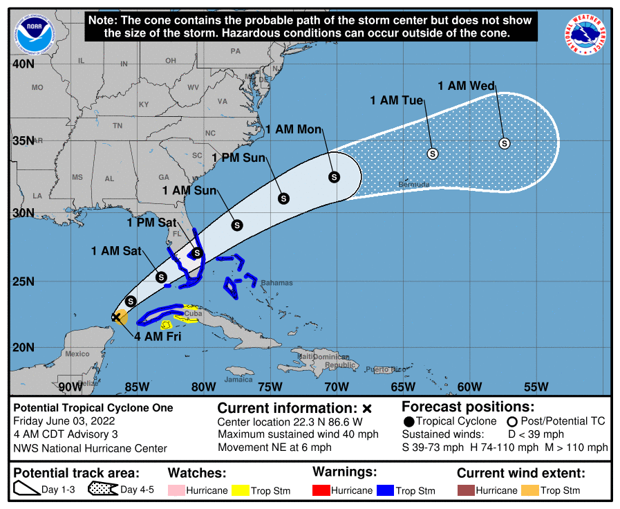
At 700 AM CDT (1200 UTC), the disturbance was centered near latitude
22.4 North, longitude 86.8 West. The system is moving toward the
northeast near 6 mph (9 km/h), and this general motion with an
increase in forward speed is expected to begin later today and
continue through Sunday. On the forecast track, the system is
forecast to move across the southeastern Gulf of Mexico through
tonight, across the southern and central portions of the Florida
Peninsula on Saturday, and then over the southwestern Atlantic north
of the northwestern Bahamas Saturday afternoon through Sunday.
Data from an Air Force Reserve Hurricane Hunter aircraft indicate
that maximum sustained winds remain near 40 mph (65 km/h) with
higher gusts. The system is expected to develop a well-defined
center and become a tropical storm later today, and some slight
strengthening is possible while it approaches Florida today and
tonight. Additional strengthening is possible after the system
moves east of Florida over the western Atlantic late Saturday and
Sunday.
* Formation chance through 48 hours…high…90 percent.
* Formation chance through 5 days…high…90 percent.
Tropical-storm-force winds extend outward up to 60 miles (95 km) to
the east of the center.
The estimated minimum central pressure is 1002 mb (29.59 inches).
HAZARDS AFFECTING LAND
———————-
Key messages for Potential Tropical Cyclone One can be found in the
Tropical Cyclone Discussion under AWIPS header MIATCDAT1, WMO
header WTNT41 KNHC, and on the web at
hurricanes.gov/graphics_at1.shtml?key_messages.
RAINFALL: The potential tropical cyclone will continue to produce
heavy rains across western Cuba through today. Heavy rain will begin
to affect Central Florida, South Florida and the Keys today through
Saturday, and affect the northwestern Bahamas tonight through
Saturday. The following storm total rainfall amounts are expected:
Western Cuba: 6 to 10 inches, with isolated maxima of 14 inches.
This rain may cause life-threatening flash flooding and mudslides.
Central Florida, South Florida, and the Florida Keys: 4 to 8 inches
with maxima of 12 inches across South Florida and in the Keys. This
rain may produce considerable flash and urban flooding.
Northwestern Bahamas: 3 to 6 inches with maxima of 10 inches. This
rain may produce flash and urban flooding.
WIND: Tropical storm conditions are expected in the warning area
in Cuba later today and tonight, in Florida tonight and on Saturday,
and in the northwestern Bahamas on Saturday. Tropical storm
conditions are possible in the watch area in Cuba today and tonight.
STORM SURGE: The combination of storm surge and the tide will
cause normally dry areas near the coast to be flooded by rising
waters moving inland from the shoreline. The water could reach the
following heights above ground somewhere in the indicated areas if
the peak surge occurs at the time of high tide…
Marco Island, FL to Card Sound Bridge…1-3 ft
Middle of Longboat Key, FL to Marco Island, FL…1-2 ft
Charlotte Harbor…1-2 ft
Florida Keys and Dry Tortugas…1-2 ft
Surge-related flooding depends on the relative timing of the surge
and the tidal cycle, and can vary greatly over short distances. For
information specific to your area, please see products issued by
your local National Weather Service forecast office.
TORNADOES: Isolated tornadoes are possible over South Florida
beginning this evening and continuing through Saturday.
Hurricane Tax Holiday
Now through June 10th, take advantage of the Tax Free Holiday to purchase key disaster preparedness items tax free. These items include:
- $1,000 or less
- Portable generators used to provide light or communications or to preserve food in a power outage
- $100 or less
- Tarpaulins or other flexible waterproof sheeting
- Ground anchor systems
- Portable pet kennels
- $70 or less
- Smoke detectors or smoke alarms
- Fire extinguishers
- Carbon monoxide detectors
- $60 or less
- Nonelectric food storage coolers
- Portable power banks
- $50 or less
- Portable self-powered radios, two-way radios, or weather-band radios
- Gas or diesel fuel tanks
- Batteries, including rechargeable batteries, listed sizes only:
- AA-cell
- AAA-cell
- C-cell
- D-cell
- 6-volt
- 9-volt
- $40 or less
- Portable self-powered light sources
- Pet beds
- $30 or less
- Bags of dry pet food weighing 15 or fewer pounds
- $20 or less
- • Reusable ice
- Leashes, collars, and muzzles for pets
- Pet pads
- $15 or less
- Manual can openers
- Collapsible or travel-sized food or water bowls for pets
- Cat litter pans
- Pet waste disposal bags
- Hamster or rabbit substrate
- $2 or less
- Cans or pouches of wet pet food


