

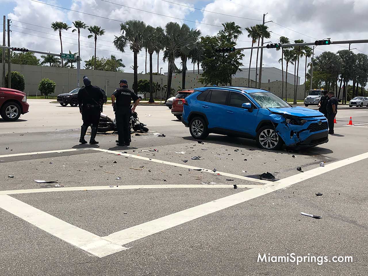
According to a Florida Department of Transportation memo sent to Virginia Gardens Mayor, Spencer Deno, the deadly intersection at NW 36th Street and Curtiss Parkway will see changes come to fruition this summer. According to the memo, some of the changes are expected to be completed by July 17, 2021.
As we had reported earlier, the Florida Department of Transportation (FDOT) had issued an initial draft report that agreed with Mayor Deno’s assessment. Here are the recommendations from FDOT:
- Modify the eastbound left-turn movement from protected/permissive operations to protected only operations. Implementing protected only operations is expected to reduce the number of left-turn crashes at the study intersection. This modification in signal operation is not expected to significantly impact the overall intersection level of service. Traffic operations are expected to remain as LOS D during peak periods – similar to existing conditions.
- Install signal head backplates with reflectors on the eastbound and westbound approaches. This will improve visibility of traffic signals for approaching drivers.
- Install temporary speed feedback signs on the westbound approach on SR 948/NW 36th Street. This will discourage excessive speeding through the intersection and thereby reduce crash risk and severity.
- Conduct a follow up intersection study to evaluate the feasibility of adding one additional eastbound left-turn lane resulting in dual left-turn lanes under protected only conditions. This will provide additional storage for eastbound left-turn queues and improve safety by reducing the risk of queue spillback into the eastbound through lanes.
- Lastly, it is recommended that FDOT continue to monitor crashes at the intersection following the proposed modifications and note any changes in crash patterns and/or frequency.
Read the complete report below:


Executive Summary
This report documents the findings of an Intersection Qualitative Assessment and Level of Service (LOS) Analysis for the intersection of SR 948/NW 36th Street and NW 57th Avenue/Curtiss Parkway, located in Miami Dade County, Florida. The qualitative assessment and LOS Analysis was initiated following a request (CTP 2021-03-0005) received by FDOT to evaluate the feasibility of converting the eastbound left-turn movement from protected/permitted operations to protected only operations. The Qualitative Assessment and LOS Analysis included field investigations, traffic counts, analysis of crash records and level of service analysis. The following is a summary of the significant findings and conclusions from the Intersection Qualitative Assessment:
1. The study intersection operates under signal control using a four-phase signal operation plan. All left-turn movements operate under protected/permissive conditions. A redlight running camera and photo enforced sign are installed on the east side of NW 57 th Avenue/Curtiss Parkway targeting westbound traffic flow.
2. The eastbound left-turn turn bay is a single lane with a storage of approximately 470 feet. Vehicles in the eastbound left bay have limited visibility to opposing westbound through vehicles when other vehicles (particularly large trucks) are queued in the westbound left turn lane.
3. Field observations during typical AM and PM peak periods indicate that moderate to heavy delays are experienced by left-turning vehicles on the eastbound approaches of the intersection. The queues on the eastbound left-turn lane typically do not clear the intersection on the first available green indication during AM peak. Furthermore, queues spill back past the left-turn bay storage capacity and impact the eastbound through lane at various times throughout both AM and PM peaks. This spillback of queues increases the risk of rear-end collisions at the intersection.
4. The existing traffic volumes showed moderate to heavy eastbound left-turn volumes at the intersection. The eastbound left-turn volumes are approximately 264 vehicles per hour and 398 vehicles per hour during the AM and PM peaks, respectively. The eastbound through volumes are approximately 2,023 vehicles per hour and 2,111 vehicles per hour during the AM and PM peak, respectively.
5. A small number of pedestrian and bicycle activity was observed at the intersection. There were no adverse operating conditions due to pedestrians and bicyclists.
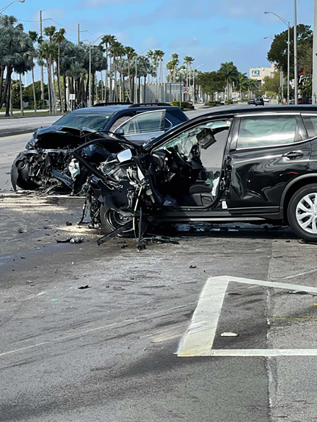
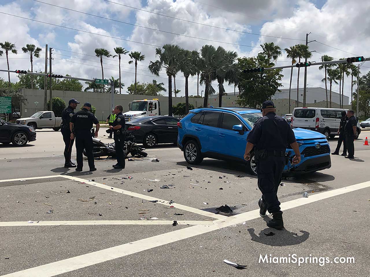
6. Crash data obtained from FDOT showed a total of 66 crashes occurred at the intersection during the three-year period from 2016 to 2018. Rear End collisions (33), sideswipe collisions (16) and left-turn collisions (11) were the leading type of crashes at the study intersection. Six of the eleven reported left-turn crashes involved eastbound left turn vehicles. It was further determined that during the period January 2019 through March 2021, there was an additional ten left-turn crashes that occurred at the intersection, and of these, eight crashes involved eastbound left-turns. In May 2019, a fatal eastbound left-turn crash resulted in two fatalities. These findings indicate that the crash risk for eastbound left-turns is relatively high when compared to other movements at the intersection.
7. Level of service analyses conducted for the intersection indicate that changing the signal operation for eastbound left turns from protected/permissive to protected only is not expected to have a major impact on the overall intersection delay. The intersection is still expected to operate at LOS D (per existing conditions), with timing adjustments as depicted in Table 5-1. The recommended timings adjustments are preliminary and final timings would have to be coordinated with Miami-Dade County to minimize intersection delays and maintain coordination along NW 36th Street.

The above findings indicate that the intersection of SR 948/NW 36th Street and NW 57th Avenue/Curtiss Parkway has experienced a relatively high number of eastbound left turn crashes resulting in serious injuries and fatalities. To reduce the risk and severity of these crashes, it is recommended that FDOT consider the following actions:
- Modify the eastbound left-turn movement from protected/permissive operations to protected only operations. Implementing protected only operations is expected to reduce the number of left-turn crashes at the study intersection. This modification in signal operation is not expected to significantly impact the overall intersection level of service. Traffic operations are expected to remain as LOS D during peak periods – similar to existing conditions.
- Install signal head backplates with reflectors on the eastbound and westbound approaches. This will improve visibility of traffic signals for approaching drivers.
- Install temporary speed feedback signs on the westbound approach on SR 948/NW 36th Street. This will discourage excessive speeding through the intersection and thereby reduce crash risk and severity.
- Conduct a follow up intersection study to evaluate the feasibility of adding one additional eastbound left-turn lane resulting in dual left-turn lanes under protected only conditions. This will provide additional storage for eastbound left-turn queues and improve safety by reducing the risk of queue spillback into the eastbound through lanes.
- Lastly, it is recommended that FDOT continue to monitor crashes at the intersection following the proposed modifications and note any changes in crash patterns and/or frequency.

Section 1
Project Overview
1.1 INTRODUCTION
RS&H, Inc. was retained by the Florida Department of Transportation (FDOT) to conduct a Qualitative Assessment and Level of Service (LOS) Analysis for the intersection at SR 948/NW 36th Street at NW 57th Avenue/Curtiss Parkway, located in Miami-Dade County, Florida (see project location map in Figure 1-1). The qualitative assessment and LOS Analysis was initiated following a request (CTP 2021-03-0005) received by FDOT to evaluate the feasibility of converting the eastbound left-turn movements from protected/permitted operations to protected only operations (see correspondence in Appendix A).
The purpose of this qualitative assessment and LOS analysis is to evaluate the request to modify the signal timings to address safety and operational concerns at the study intersection. The study involved field reviews, traffic counts, crash analyses, level of service analyses and making recommendations for improvements (if necessary) or further studies at the location.
1.2 STUDY METHODOLOGY
The study was undertaken in accordance with Task Work Order # 16 issued by FDOT dated March 4, 2021. The study methodology conformed to the following Service Type as described in the Districtwide Traffic Operations/Safety Studies (Contract CA426), Scope of Services:
Service Type 1A: Qualitative Assessment – Intersection
Service Task 6A(k): Level of Service Analyses
Section 2
Existing Conditions
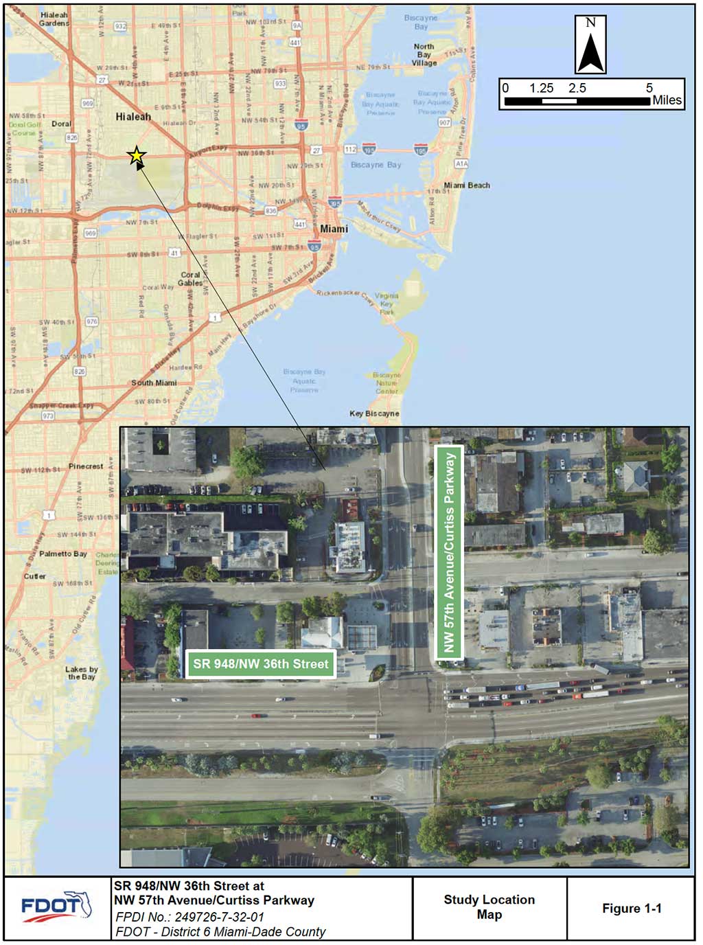
Field reviews and investigations were conducted at the intersection of NW 36th Street and NW 57th Avenue/Curtiss Parkway to document the existing roadway, safety conditions, as well as traffic operations. SR 948/NW 36th Street is identified as Section 87220000 on the State Highway System and the intersection of NW 57th Avenue/Curtiss Parkway is located at milepost (MP) 2.157. Within the study limits, NW 36th Street is classified as an urban other principal arterial with a divided median. NW 36th Street has a typical cross section consisting of six lanes – three westbound lanes and three eastbound lanes with a posted speed limit of 40 miles per hour (mph).
NW 57th Avenue/Curtiss Parkway is a four-lane divided roadway north of NW 36th Street and a two-lane divided roadway south of NW 36th Street. The posted speed limit along NW 57th Avenue/Curtiss Parkway in the vicinity of the study intersection is 30 mph.
The adjacent land uses near the study intersection are primarily commercial north of NW 36th Street and Miami International Airport is located south of NW 36th Street.
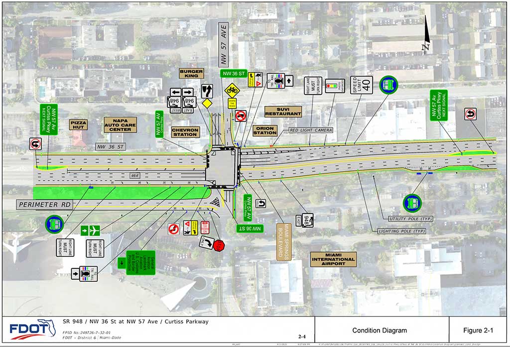
Four Miami Dade Transit bus stops servicing Route 36 and Route 132, are located along NW 36th Street in the vicinity of NW 57th Avenue/Curtiss Parkway. Two westbound bus stops are located approximately 340 feet east and 1,140 feet west of NW 57th Avenue/Curtiss Parkway, respectively. Two eastbound bust stops are located approximately 430 feet west, and 640 feet east of NW 57th Avenue/Curtiss Parkway, respectively. A condition diagram showing the study intersection with existing signage and pavement markings is depicted in Figure 2-1.
2.1 INTERSECTION GEOMETRY
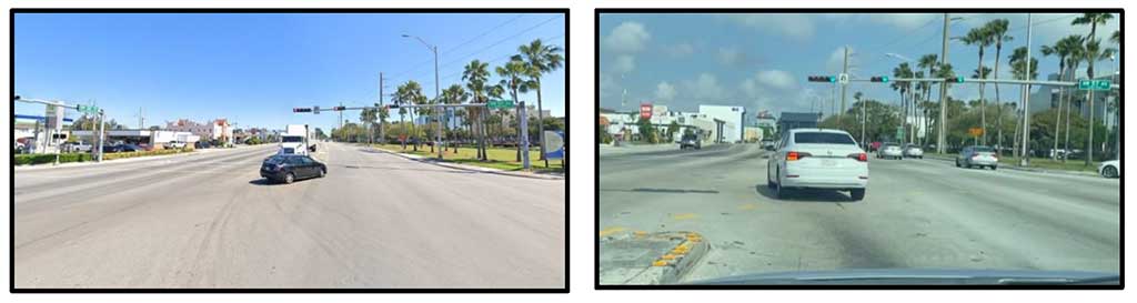
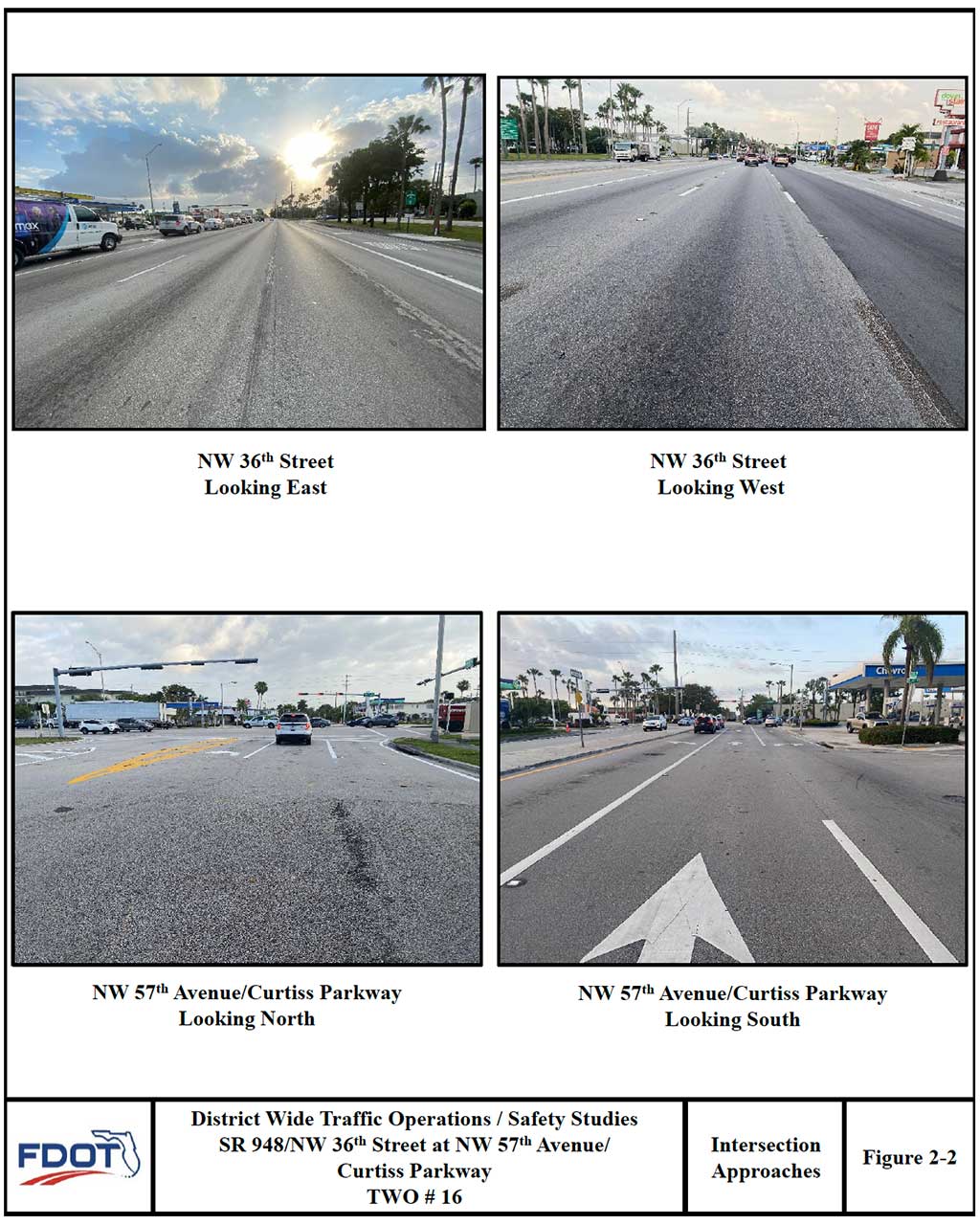
The intersection of SR 948/NW 36th Street and NW 57th Avenue/Curtiss Parkway is a four legged signalized intersection. The lane configuration of the study intersection is described below. The photographs in Figure 2-2 depict the existing lane configurations at the study intersection.
Northbound: This approach consists of one exclusive left-turn lane + one through (NW 57 th Ave) lane + one shared through/right-turn lane.
Southbound: This approach consists of one exclusive left-turn lane + one (NW 57 th Ave) through lane + one exclusive right-turn lane.
Eastbound: This approach consists of one exclusive left-turn lane + three (NW 36 th St) through lanes + one exclusive right-turn lane.
Westbound: This approach consists of one exclusive left-turn lane + three (NW 36 th St) through lanes + one exclusive right-turn lane.
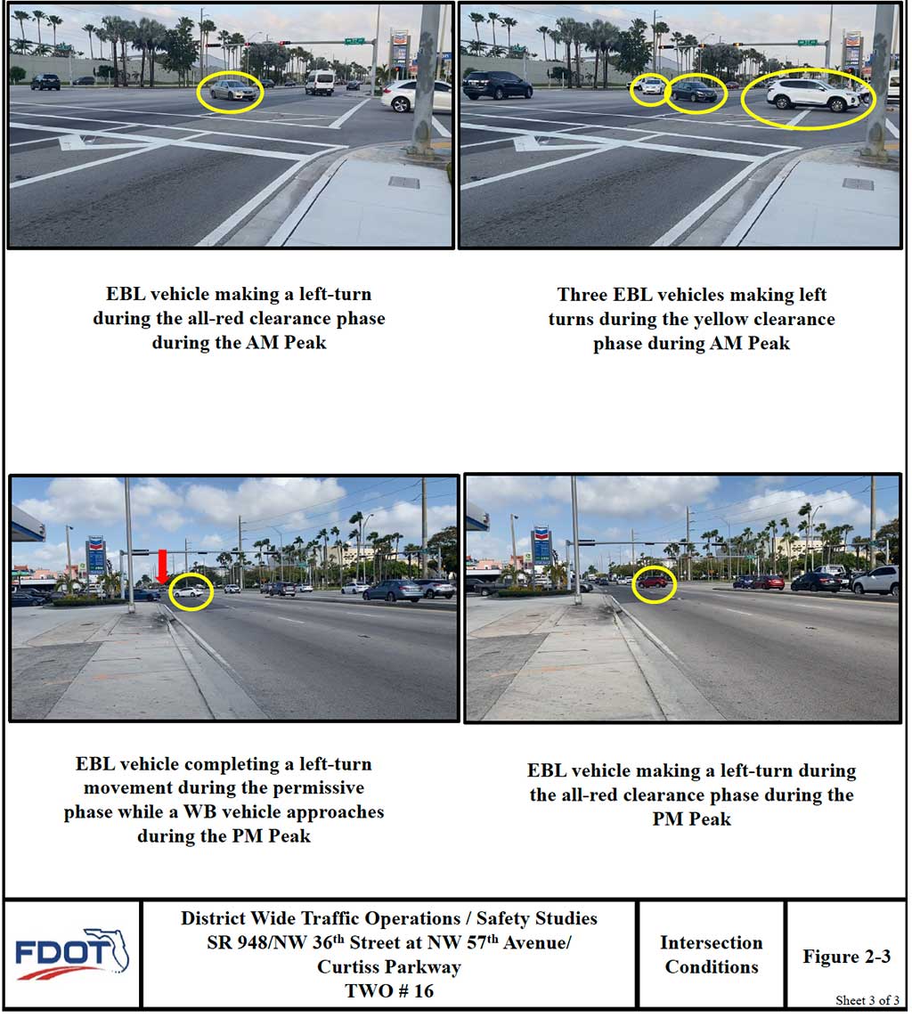
The study location is characterized by flat terrain. The horizontal alignment of the westbound approach is along a curve. Eastbound left turn vehicles have limited visibility to opposing westbound through vehicles when other vehicles (particularly large trucks) are queued in the westbound left turn lane (see Photographs below ). This may be a contributing cause for crashes at the location. Sidewalks are provided along both sides of NW 36th Street within the study intersection. Sidewalks are also provided along both sides of NW 57th Avenue/Curtiss Parkway north of the intersection and only on the east side of NW 57th Avenue/Curtiss Parkway south of the intersection.
2.2 PAVEMENT CONDITIONS AND MARKINGS
The road surface at the study location is constructed of asphaltic concrete and the pavement surface is in good condition. Standard pavement markings are installed at the intersection and are in fair to good condition. Pedestrian crosswalk lines and pedestrian ramps are installed on all legs of the intersection except for the west leg.
2.3 TRAFFIC CONTROL
The intersection of NW 36th Street and NW 57th Avenue/Curtiss Parkway is signalized. All left-turn movements of the intersection operate under protected/permissive conditions. There is a southbound right-turn overlap phase that is allowed to go during the eastbound left-turn protected phase. The signal operation plan of the intersection is shown on Table 2-1 and the timing details are shown in Appendix B.
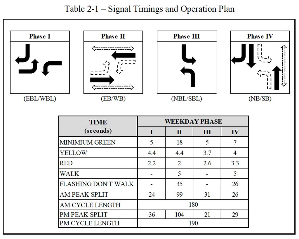
Signal heads are mounted on mast arm assemblies and all signal displays are in good condition. Signal heads on all approaches have no backplates. Countdown pedestrian signals with push button as well as pedestrian ramps are installed at the intersection. The pedestrian signal heads are installed on ground mounted poles on all corners of the intersection. Traffic signs located within the intersection were found to be visible and generally well maintained except for the“No Truck” sign located on the northeast corner of the intersection. A pedestrian crossing sign with supplemental right turn vehicles yield to pedestrian sign is installed on the eastbound and westbound approach of the intersection.
A red light running camera and a photo enforced sign are installed on NW 36th Street just east of NW 57th Avenue /Curtiss Parkway targeting westbound vehicles.
2.4 ACCESS MANAGEMENT
The study segment of NW 36th Street has been assigned Access Class 5 per the District Access Management Classification System and Standards. Restrictive medians are permitted for Access Classes 5 facilities, and with speed limit of 40 mph, permit a minimum signal spacing of 0.25 miles (or 1,320 feet), respectively. The nearest signalized intersection to the east is located at NW 5300 Block which is approximately 0.33 miles (1,740 feet) from the subject intersection. The nearest signalized intersection to the west is located at SW 66th Avenue and is approximately 0.88 miles (4,650 feet) from the subject intersection. The existing signal spacing along NW 36th Street satisfies the minimum criteria specified by the access management standards.
was efficient as upstream vehicle platoons arrived at the intersection during the westbound through green phase. Due to the efficient coordination and volume of westbound through traffic, very few adequate gaps were available for eastbound left turns to safely clear the intersection during the permissive phase. This lack of adequate gaps resulted in only one or two vehicles completing the left turn movement during the permissive phase.Moderate traffic was observed along NW 57th Avenue/Curtiss Parkway with southbound being the more heavily traveled direction. Minor delays with queues of approximately five to tenvehicles were observed along the southbound approach, while approximately one to five vehicles were observed in the northbound approach of the intersection. On most occasions, queues on the northbound and southbound approaches cleared the intersection during the first available green indication.
PM Peak Period (4:00 PM to 6:00 PM)
During the PM peak period, moderate to heavy traffic was observed along NW 36th Street with eastbound being the most heavily traveled direction. Generally, queues of approximately fifteen vehicles or more were observed along the westbound approach of the intersection. The westbound queues typically cleared the intersection within the first available green indication.
The westbound left-turn movement experienced minor delays with queues of approximately two to five vehicles and queues typically cleared the intersection during the first available green indication.
The eastbound through queues along NW 36th Street were observed to be approximately ten to fifteen vehicles and would typically clear the intersection during the first available green indication. Efficient coordination was observed in the eastbound through direction with upstream vehicle platoons arriving during the green phase at the intersection. Moderate to heavy delays were observed for the eastbound left-turn vehicles during the PM peak period.
The left-turn queues on the eastbound approach generally consisted of approximately fifteen to twenty vehicles. On occasion, the eastbound left-turn lane storage would reach capacity and vehicles would spill back and block the inside eastbound through lane. Ten to fifteen vehicles would typically complete the left-turn movement during the protected phase. During the PM peak, the permissive eastbound left-turn was more effective due to more gap opportunities in the opposing westbound through traffic. Cycle failures were observed during the PM peak for eastbound left-turn vehicles.
Moderate traffic was observed along NW 57th Avenue/Curtiss Parkway with southbound being the more heavily traveled direction. Minor delays with queues of approximately five to ten vehicles were observed along the southbound approach, while approximately one to five vehicles were observed in the northbound approach of the intersection. On most occasions, queues along both the northbound and southbound approaches cleared the intersection during the first available green indication.
2.6 PEDESTRIANS/BICYCLES
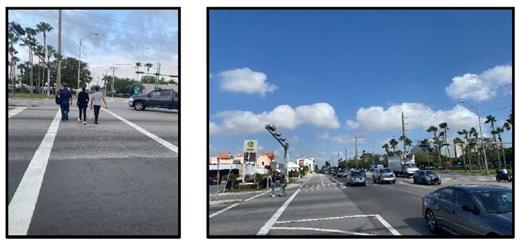
A few pedestrians and bicyclists were observed in the vicinity of the intersection during both the AM and PM observation periods (see Photographs below). Pedestrians and bicyclists were observed crossing NW 36th Street and NW 57th Avenue/Curtiss Parkway using the marked crosswalks at the intersection. In general, pedestrian and bicycle activities did not generate any significant operational or safety issues at the intersection.

Section 3
Data Collection
3.1 MECHANICAL TRAFFIC COUNTS
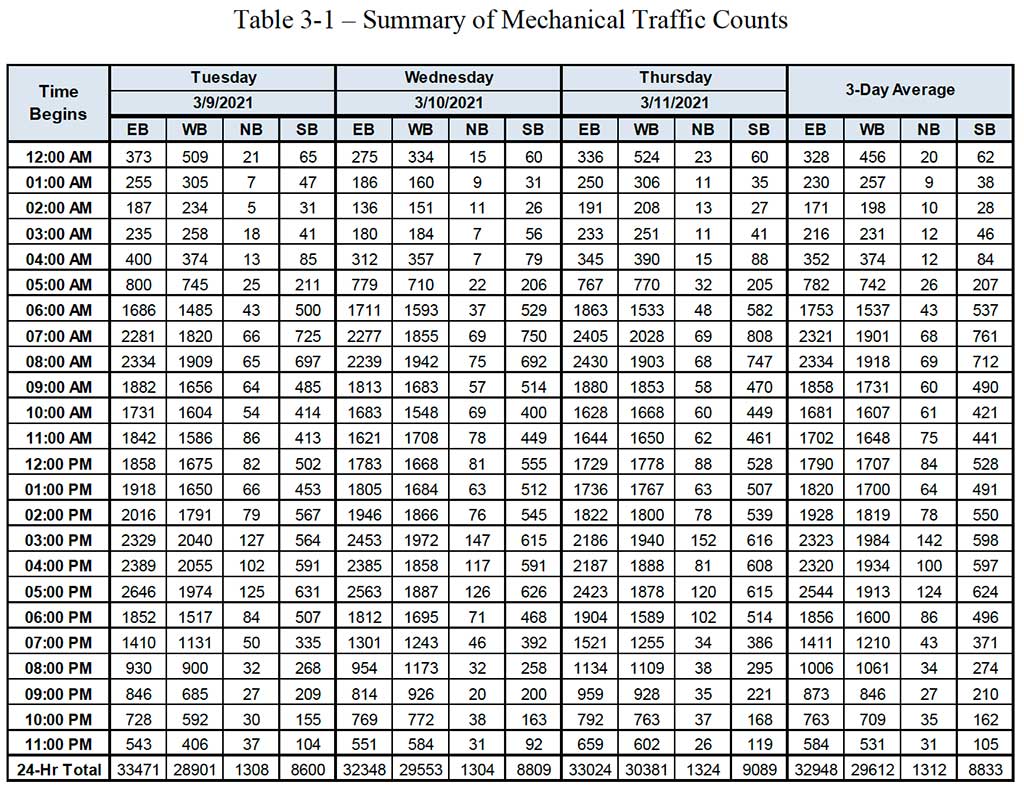
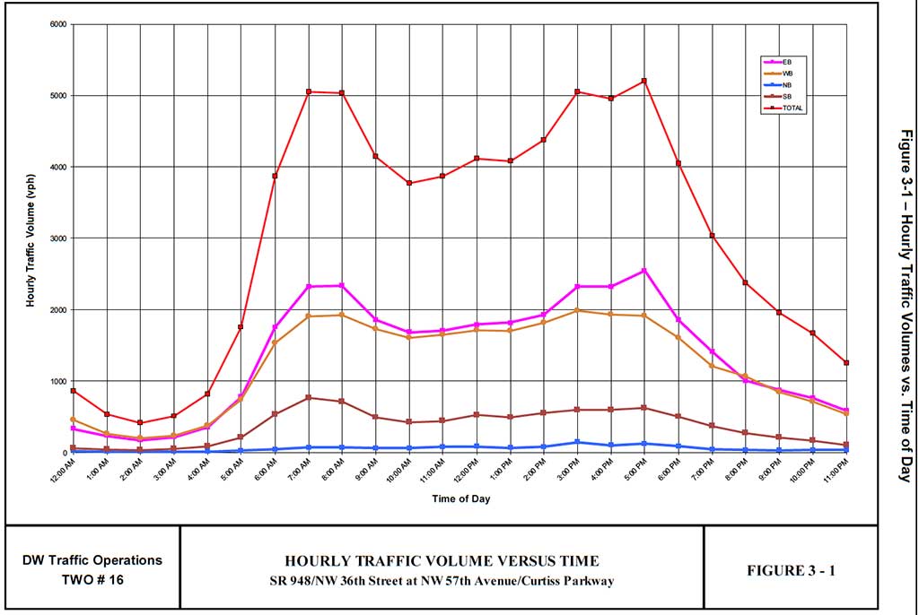
Mechanical traffic counts were collected on all four approaches of the study intersection. These counts were collected for a continuous 72-hour period extending from Tuesday, March 9, 2021 through Thursday, March 11, 2021. Detailed results from the mechanical counts are presented in Appendix D. Table 3-1 summarizes the results of the mechanical traffic counts. The graph in Figure 3-1 shows the variation of hourly traffic volume versus time of day for a typical weekday (Tuesday through Thursday).
3.2 MANUAL TURNING MOVEMENT COUNTS
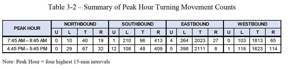
Four-hour intersection turning movement counts were collected at the study intersection on Tuesday, March 9, 2021. The data was gathered during typical weekday traffic periods:
morning peak (7:00 AM to 9:00 AM) and afternoon peak (4:00 PM to 6:00 PM).
Detailed results from the turning movement counts are shown in Appendix E and the results are summarized in Table 3-2. The data in Table 3-2 shows the traffic volumes for the AM (7:45 – 8:45) and PM (4:45 – 5:45) peak hours as determined from the turning movement counts (four highest consecutive 15-minute intervals).
The data in Table 3-2 shows high eastbound left-turn volumes during the AM (264) and PM (398) peak hours. The eastbound through volume is relatively moderate in both peaks with 2,023 vehicles during the AM peak and during the PM peak with 2,111 vehicles. The data also shows relatively moderate westbound and volumes during the AM and PM (1,813 and 1,623) peak hours, respectively. These volumes are consistent with the observations during the AM and PM peak period field visits.
4.1 CRASH SUMMARY
Crash data for the three-year period January 1, 2016 through December 31, 2018 were obtained from FDOT’s Crash Analysis Reporting System (CARS). The raw crash data obtained from CARS was refined as necessary by reviewing hard copy police reports (also obtained from FDOT). the data collected was used to prepare Crash Summary Reports and Collision Diagrams for the study intersection (See Appendix F).
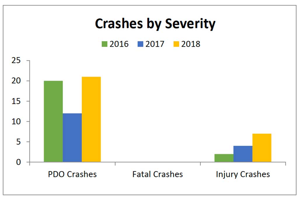
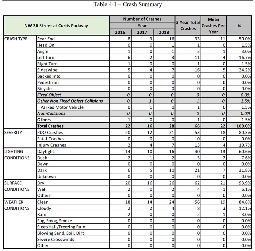
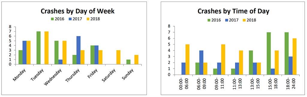
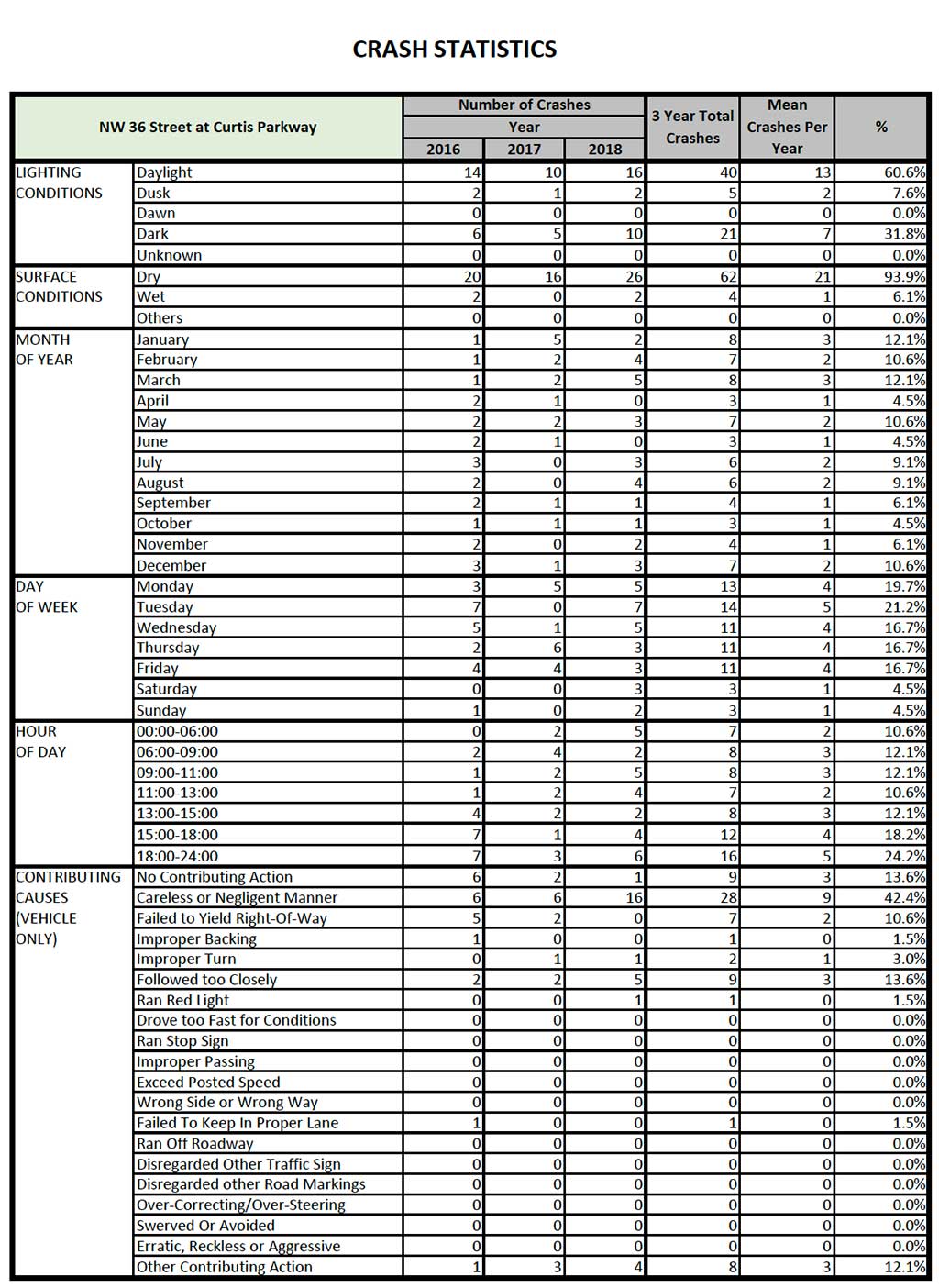
The crash statistics for study intersection (FDOT roadway section 87220000 from MP 2.107 to MP 2.207) is summarized in Table 4-1. The data shows a total of 66 crashes occurring within the study intersection during the three-year period (2016 to 2018). There were 22 crashes reported in 2016, 16 in 2017 and 28 in 2018. During the three-year period, 13 (or 19%) of the crashes involved injuries and no fatalities were reported.
Rear End collisions were the leading type of crashes reported at the intersection, accounting for 33 (or 50%) of the crashes experienced during the three-year period. Sideswipe collisions and Left-Turn collisions were the second and third leading types of crashes, accounting for 16 (or 24%) and 11 (or 16%) respectively, of the crashes experienced during the three-year period.
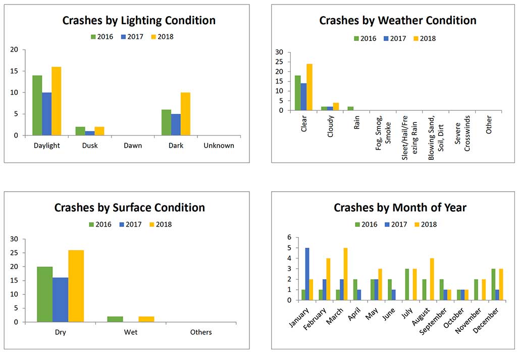
Most of the crashes occurred during daytime (60%), dry surface conditions (94%) and clear weather conditions (85%).
Table 4-1 also shows calculations for the test factor at the location for each of the three years 2016 through 2018. The test factor determines the confidence that the study location is a high crash location when compared to similar locations throughout FDOT, District 6.
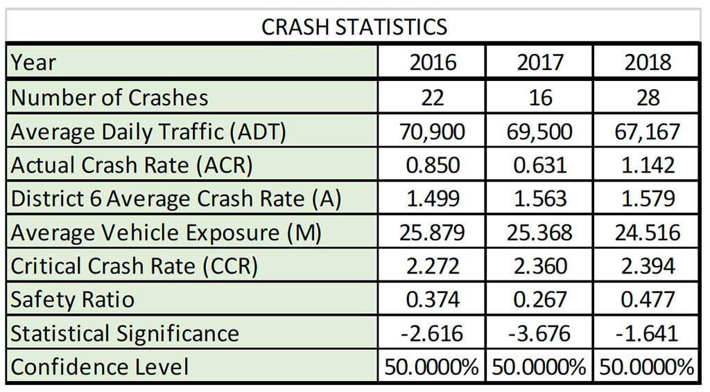
The test factor procedure (shown below) is valid for a minimum of eight crashes occurring in any one year. Given that the study location experienced eight crashes or more during each year, the test factor procedure is applicable for all three years. The test factor is calculated from the following relationships:
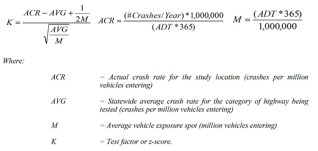
The computed test factors for the years 2016, 2017 and 2018 were -2.616, -3.676 and -1.641, respectively. Based on the cumulative standard normal distribution curve, each of these test factors produced a confidence level of less than 50% for all three years. Hence, during the period 2016 to 2018, it can be concluded that the study intersection did not experience an abnormally high crash rate when compared to similar intersections in FDOT District 6.
4.2 PREDOMINANT CRASH PATTERNS AND PROBABLE CAUSAL FACTORS
FDOT’s publication titled “Expected Values Analysis, September 2018” gives the expected crash rates for similar intersections in Miami-Dade County. This reference document is used to compare the actual crash rates at the study intersection with the expected crash rates for similar intersections in Miami-Dade County. Intersections with configurations similar to the study location (signalized, 6 lanes x 4 lanes (north leg) x 2 lanes (south leg)) are not covered in the Expected Value Analysis reference document. Hence, the use of the Expected Values Analysis was not applicable for this study location.
However, an inspection of the crash data and collision diagrams show that six of the eleven Left-Turn collisions reported at the intersection during the three-year period (2016 -2018) were eastbound left-turn crashes. Furthermore, an additional search was conducted using
Signal4Analytics database to investigate crashes reported at the intersection from January 2019 through March 2021 (see Appendix F). Through this research, it was determined, that during the 2 year and 3-month period an additional ten left-turn crashes occurred at the intersection with eight of these crashes identified as eastbound left-turn crashes. In addition, a fatal crash occurred on May 27, 2019. The fatal crash occurred at 12:35 PM under daylight, dry pavement and clear weather conditions. The fatal crash, which resulted in two fatalities, happened when an eastbound left-turn vehicle collided with a westbound through vehicle that was traveling at reportedly high speed.
Section 5
Level of Service Analysis
Level of service analyses were conducted for the intersection of NW 36th Street and NW 57th Avenue/Curtiss Parkway to assess the expected traffic operating conditions at the location for three alternative traffic control scenarios:
1. Existing signal operation plan and timings.
2. Alternative 1 – Signal optimization with existing phasing.
3. Alternative 2 – Protected eastbound left-turn phasing.
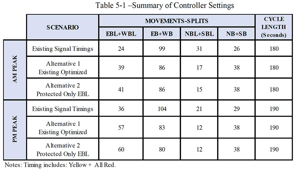
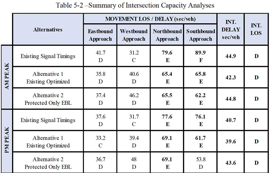
Level of service analyses were performed for the typical weekday conditions during the AM and PM peak periods based on the procedures outlined in the Highway Capacity Manual, 6th Edition. Level of service analyses were performed using Synchro 10. Synchro models were developed for the AM and PM peak periods for the alternative traffic control scenarios. The cycle lengths used for the analyses were consistent with the existing cycles used for the control section in which the study intersection is installed. No changes were made to the clearance intervals. Synchro 10 parameters were adjusted, as necessary, to reflect observed traffic operating conditions. The controller settings associated with each traffic control strategy are shown in Table 5-1. Results from the level of service analyses are summarized in Table 5-2 and details are included in Appendix G.
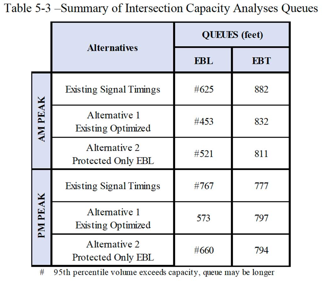
The results from the capacity analyses indicated that the overall existing intersection operates at Level of Service (LOS) D (44.9 secs) during the AM peak and LOS D (43.6 secs) during the PM peak. The eastbound approach of the intersection operates at LOS D during both the AM peak (EB-41.7 secs) and the PM peak (EB-37.6 secs). The eastbound left-turn movement operates at LOS F in the AM (EBL-156.6 secs) peak and in the PM (EBL-118.6 secs) peak, with AM and PM queues expected to extend past storage capacity of approximately 470 feet (AM- Over 620 feet and PM-Over 760 feet).
The analyses for Alternative 1 (optimization) show that the overall intersection operates at Level of Service (LOS) D (42.3 secs) during the AM peak and LOS D (39.6 secs) during the PM peak. The eastbound approach of the intersection operates at LOS D during both the AM peak (EB-35.8 secs) and the PM peak (EB-33.2 secs). The eastbound left-turn movement
operates at LOS F in the AM (EBL-84.7 secs) peak and LOS E in the PM (EBL-78.0 secs) peak, with PM queues expected to extend past storage capacity of approximately 470 feet (AM Over 450 feet and PM-575 feet).
The analyses for Alternative 2 (protected only EBL) show that the overall intersection operates at Level of Service (LOS) D (44.8 secs) during the AM peak and LOS D (43.6 secs) during the PM peak. The eastbound approach of the intersection operates at LOS D during both the AM peak (EB-37.4 secs) and the PM peak (EB-36.7 secs). The eastbound left-turn movement operates at LOS F in the AM (EBL-108.5 secs) peak and LOS E in the PM (EBL-98.5 secs) peak, with AM & PM queues expected to extend past storage capacity of approximately 470 feet (AM- Over 520 feet and PM-Over 660 feet).
Section 6
Conclusions and Recommendations
The Qualitative Assessment at the intersection of SR 948/NW 36th Street and NW 57th Avenue/Curtiss Parkway resulted in the following findings:
1. The study intersection operates under signal control using a four-phase signal operation plan. All left-turn movements operate under protected/permissive conditions. A redlight running camera and photo enforced sign are installed on the east side of NW 57th Avenue/Curtiss Parkway targeting westbound traffic flow.
2. The eastbound left-turn turn bay is a single lane with a storage of approximately 470 feet. Vehicles in the eastbound left bay have limited visibility to opposing westbound through vehicles when other vehicles (particularly large trucks) are queued in the westbound left turn lane.
3. Field observations during typical AM and PM peak periods indicate that moderate to heavy delays are experienced by left-turning vehicles on the eastbound approaches of the intersection. The queues on the eastbound left-turn lane typically do not clear the intersection on the first available green indication during AM peak. Furthermore, queues spill back past the left-turn bay storage capacity and impact the eastbound through lane at various times throughout both AM and PM peaks. This spillback of queues increases the risk of rear-end collisions at the intersection.
4. The existing traffic volumes showed moderate to heavy eastbound left-turn volumes at the intersection. The eastbound left-turn volumes are approximately 264 vehicles per hour and 398 vehicles per hour during the AM and PM peaks, respectively. The eastbound through volumes are approximately 2,023 vehicles per hour and 2,111 vehicles per hour during the AM and PM peak, respectively.
5. A small number of pedestrian and bicycle activity was observed at the intersection. There were no adverse operating conditions due to pedestrians and bicyclists.
6. Crash data obtained from FDOT showed a total of 66 crashes occurred at the intersection during the three-year period from 2016 to 2018. Rear End collisions (33), sideswipe collisions (16) and left-turn collisions (11) were the leading type of crashes at the study intersection. Six of the eleven reported left-turn crashes involved eastbound left turn vehicles. It was further determined that during the period January 2019 through March 2021, there was an additional ten left-turn crashes that occurred at the intersection, and of these, eight crashes involved eastbound left-turns. In May 2019, a fatal eastbound left-turn crash resulted in two fatalities. These findings indicate that the crash risk for eastbound left-turns is relatively high when compared to other movements at the intersection.
7. Level of service analyses conducted for the intersection indicate that changing the signal operation for eastbound left turns from protected/permissive to protected only is not expected to have a major impact on the overall intersection delay. The intersection is still expected to operate at LOS D (per existing conditions), with timing adjustments as depicted in Table 5-1. The recommended timings adjustments are preliminary and final timings would have to be coordinated with Miami-Dade County to minimize intersection delays and maintain coordination along NW 36th Street.
The above findings indicate that the intersection of SR 948/NW 36th Street and NW 57th Avenue/Curtiss Parkway has experienced a relatively high number of eastbound left turn crashes resulting in serious injuries and fatalities. To reduce the risk and severity of these crashes, it is recommended that FDOT consider the following actions:
• Modify the eastbound left-turn movement from protected/permissive operations to protected only operations. Implementing protected only operations is expected to reduce the number of left-turn crashes at the study intersection. This modification in signal operation is not expected to significantly impact the overall intersection level of service. Traffic operations are expected to remain as LOS D during peak periods – similar to existing conditions.
• Install signal head backplates with reflectors on the eastbound and westbound approaches. This will improve visibility of traffic signals for approaching drivers.
• Install temporary speed feedback signs on the westbound approach on SR 948/NW 36th Street. This will discourage excessive speeding through the intersection and thereby reduce crash risk and severity.
• Conduct a follow up intersection study to evaluate the feasibility of adding one additional eastbound left-turn lane resulting in dual left-turn lanes under protected only conditions. This will provide additional storage for eastbound left-turn queues and improve safety by reducing the risk of queue spillback into the eastbound through lanes.
• Lastly, it is recommended that FDOT continue to monitor crashes at the intersection following the proposed modifications and note any changes in crash patterns and/or frequency.
As you know, there have been several accidents at the intersection of NW 36th Street and Curtiss Parkway. As a result, the Mayor of Virginia Gardens, Spencer Deno, has requested that the left turn signal on the eastbound lanes of the intersection be switched to a left turn only on the green arrow. The idea is to prevent left turns while there’s still oncoming traffic and prevent more people from getting hurt at this intersection.
The Florida Department of Transportation (FDOT) has issued an initial draft report.
Executive Summary
This report documents the findings of an Intersection Qualitative Assessment and Level of Service (LOS) Analysis for the intersection of SR 948/NW 36th Street and NW 57th Avenue/Curtiss Parkway, located in Miami Dade County, Florida. The qualitative assessment and LOS Analysis was initiated following a request (CTP 2021-03-0005) received by FDOT to evaluate the feasibility of converting the eastbound left-turn movement from protected/permitted operations to protected only operations. The Qualitative Assessment and LOS Analysis included field investigations, traffic counts, analysis of crash records and level of service analysis. The following is a summary of the significant findings and conclusions from the Intersection Qualitative Assessment:
1. The study intersection operates under signal control using a four-phase signal operation plan. All left-turn movements operate under protected/permissive conditions. A redlight running camera and photo enforced sign are installed on the east side of NW 57 th Avenue/Curtiss Parkway targeting westbound traffic flow.
2. The eastbound left-turn turn bay is a single lane with a storage of approximately 470 feet. Vehicles in the eastbound left bay have limited visibility to opposing westbound through vehicles when other vehicles (particularly large trucks) are queued in the westbound left turn lane.
3. Field observations during typical AM and PM peak periods indicate that moderate to heavy delays are experienced by left-turning vehicles on the eastbound approaches of the intersection. The queues on the eastbound left-turn lane typically do not clear the intersection on the first available green indication during AM peak. Furthermore, queues spill back past the left-turn bay storage capacity and impact the eastbound through lane at various times throughout both AM and PM peaks. This spillback of queues increases the risk of rear-end collisions at the intersection.
4. The existing traffic volumes showed moderate to heavy eastbound left-turn volumes at the intersection. The eastbound left-turn volumes are approximately 264 vehicles per hour and 398 vehicles per hour during the AM and PM peaks, respectively. The eastbound through volumes are approximately 2,023 vehicles per hour and 2,111 vehicles per hour during the AM and PM peak, respectively.
5. A small number of pedestrian and bicycle activity was observed at the intersection. There were no adverse operating conditions due to pedestrians and bicyclists.
6. Crash data obtained from FDOT showed a total of 66 crashes occurred at the intersection during the three-year period from 2016 to 2018. Rear End collisions (33), sideswipe collisions (16) and left-turn collisions (11) were the leading type of crashes at the study intersection. Six of the eleven reported left-turn crashes involved eastbound left turn vehicles. It was further determined that during the period January 2019 through March 2021, there was an additional ten left-turn crashes that occurred at the intersection, and of these, eight crashes involved eastbound left-turns. In May 2019, a fatal eastbound left-turn crash resulted in two fatalities. These findings indicate that the crash risk for eastbound left-turns is relatively high when compared to other movements at the intersection.
7. Level of service analyses conducted for the intersection indicate that changing the signal operation for eastbound left turns from protected/permissive to protected only is not expected to have a major impact on the overall intersection delay. The intersection is still expected to operate at LOS D (per existing conditions), with timing adjustments as depicted in Table 5-1. The recommended timings adjustments are preliminary and final timings would have to be coordinated with Miami-Dade County to minimize intersection delays and maintain coordination along NW 36th Street.
The above findings indicate that the intersection of SR 948/NW 36th Street and NW 57th Avenue/Curtiss Parkway has experienced a relatively high number of eastbound left turn crashes resulting in serious injuries and fatalities. To reduce the risk and severity of these crashes, it is recommended that FDOT consider the following actions:
- Modify the eastbound left-turn movement from protected/permissive operations to protected only operations. Implementing protected only operations is expected to reduce the number of left-turn crashes at the study intersection. This modification in signal operation is not expected to significantly impact the overall intersection level of service. Traffic operations are expected to remain as LOS D during peak periods – similar to existing conditions.
- Install signal head backplates with reflectors on the eastbound and westbound approaches. This will improve visibility of traffic signals for approaching drivers.
- Install temporary speed feedback signs on the westbound approach on SR 948/NW 36th Street. This will discourage excessive speeding through the intersection and thereby reduce crash risk and severity.
- Conduct a follow up intersection study to evaluate the feasibility of adding one additional eastbound left-turn lane resulting in dual left-turn lanes under protected only conditions. This will provide additional storage for eastbound left-turn queues and improve safety by reducing the risk of queue spillback into the eastbound through lanes.
- Lastly, it is recommended that FDOT continue to monitor crashes at the intersection following the proposed modifications and note any changes in crash patterns and/or frequency.
Section 1
Project Overview
1.1 INTRODUCTION
RS&H, Inc. was retained by the Florida Department of Transportation (FDOT) to conduct a Qualitative Assessment and Level of Service (LOS) Analysis for the intersection at SR 948/NW 36th Street at NW 57th Avenue/Curtiss Parkway, located in Miami-Dade County, Florida (see project location map in Figure 1-1). The qualitative assessment and LOS Analysis was initiated following a request (CTP 2021-03-0005) received by FDOT to evaluate the feasibility of converting the eastbound left-turn movements from protected/permitted operations to protected only operations (see correspondence in Appendix A).
The purpose of this qualitative assessment and LOS analysis is to evaluate the request to modify the signal timings to address safety and operational concerns at the study intersection. The study involved field reviews, traffic counts, crash analyses, level of service analyses and making recommendations for improvements (if necessary) or further studies at the location.
1.2 STUDY METHODOLOGY
The study was undertaken in accordance with Task Work Order # 16 issued by FDOT dated March 4, 2021. The study methodology conformed to the following Service Type as described in the Districtwide Traffic Operations/Safety Studies (Contract CA426), Scope of Services:
Service Type 1A: Qualitative Assessment – Intersection
Service Task 6A(k): Level of Service Analyses
Section 2
Existing Conditions
Field reviews and investigations were conducted at the intersection of NW 36th Street and NW 57th Avenue/Curtiss Parkway to document the existing roadway, safety conditions, as well as traffic operations. SR 948/NW 36th Street is identified as Section 87220000 on the State Highway System and the intersection of NW 57th Avenue/Curtiss Parkway is located at milepost (MP) 2.157. Within the study limits, NW 36th Street is classified as an urban other principal arterial with a divided median. NW 36th Street has a typical cross section consisting of six lanes – three westbound lanes and three eastbound lanes with a posted speed limit of 40 miles per hour (mph).
NW 57th Avenue/Curtiss Parkway is a four-lane divided roadway north of NW 36th Street and a two-lane divided roadway south of NW 36th Street. The posted speed limit along NW 57th Avenue/Curtiss Parkway in the vicinity of the study intersection is 30 mph.
The adjacent land uses near the study intersection are primarily commercial north of NW 36th Street and Miami International Airport is located south of NW 36th Street.
Four Miami Dade Transit bus stops servicing Route 36 and Route 132, are located along NW 36th Street in the vicinity of NW 57th Avenue/Curtiss Parkway. Two westbound bus stops are located approximately 340 feet east and 1,140 feet west of NW 57th Avenue/Curtiss Parkway, respectively. Two eastbound bust stops are located approximately 430 feet west, and 640 feet east of NW 57th Avenue/Curtiss Parkway, respectively. A condition diagram showing the study intersection with existing signage and pavement markings is depicted in Figure 2-1.
2.1 INTERSECTION GEOMETRY
The intersection of SR 948/NW 36th Street and NW 57th Avenue/Curtiss Parkway is a fourlegged
signalized intersection. The lane configuration of the study intersection is described
below. The photographs in Figure 2-2 depict the existing lane configurations at the study
intersection.
Northbound: This approach consists of one exclusive left-turn lane + one through
(NW 57 th Ave) lane + one shared through/right-turn lane.
Southbound: This approach consists of one exclusive left-turn lane + one
(NW 57 th Ave) through lane + one exclusive right-turn lane.
Eastbound: This approach consists of one exclusive left-turn lane + three
(NW 36 th St) through lanes + one exclusive right-turn lane.
Westbound: This approach consists of one exclusive left-turn lane + three
(NW 36 th St) through lanes + one exclusive right-turn lane.
The study location is characterized by flat terrain. The horizontal alignment of the westbound
approach is along a curve. Eastbound left turn vehicles have limited visibility to opposing
westbound through vehicles when other vehicles (particularly large trucks) are queued in the
westbound left turn lane (see Photographs below ). This may be a contributing cause for
crashes at the location. Sidewalks are provided along both sides of NW 36th Street within the
study intersection. Sidewalks are also provided along both sides of NW 57th Avenue/Curtiss Parkway north of the intersection and only on the east side of NW 57th Avenue/Curtiss Parkway south of the intersection.
2.2 PAVEMENT CONDITIONS AND MARKINGS
The road surface at the study location is constructed of asphaltic concrete and the pavement surface is in good condition. Standard pavement markings are installed at the intersection and are in fair to good condition. Pedestrian crosswalk lines and pedestrian ramps are installed on all legs of the intersection except for the west leg.
2.3 TRAFFIC CONTROL
The intersection of NW 36th Street and NW 57th Avenue/Curtiss Parkway is signalized. All
left-turn movements of the intersection operate under protected/permissive conditions. There is
a southbound right-turn overlap phase that is allowed to go during the eastbound left-turn
protected phase. The signal operation plan of the intersection is shown on Table 2-1 and the
timing details are shown in Appendix B.
Signal heads are mounted on mast arm assemblies and all signal displays are in good condition.
Signal heads on all approaches have no backplates. Countdown pedestrian signals with push
button as well as pedestrian ramps are installed at the intersection. The pedestrian signal heads
are installed on ground mounted poles on all corners of the intersection. Traffic signs located
within the intersection were found to be visible and generally well maintained except for the
“No Truck” sign located on the northeast corner of the intersection. A pedestrian crossing sign
with supplemental right turn vehicles yield to pedestrian sign is installed on the eastbound and
westbound approach of the intersection.
A red light running camera and a photo enforced sign are installed on NW 36th Street just east
of NW 57th Avenue /Curtiss Parkway targeting westbound vehicles.
2.4 ACCESS MANAGEMENT
The study segment of NW 36th Street has been assigned Access Class 5 per the District Access
Management Classification System and Standards. Restrictive medians are permitted for
Access Classes 5 facilities, and with speed limit of 40 mph, permit a minimum signal spacing
of 0.25 miles (or 1,320 feet), respectively. The nearest signalized intersection to the east is
located at NW 5300 Block which is approximately 0.33 miles (1,740 feet) from the subject
intersection. The nearest signalized intersection to the west is located at SW 66th Avenue and
is approximately 0.88 miles (4,650 feet) from the subject intersection. The existing signal
spacing along NW 36th Street satisfies the minimum criteria specified by the access
management standards.
was efficient as upstream vehicle platoons arrived at the intersection during the westbound
through green phase. Due to the efficient coordination and volume of westbound through
traffic, very few adequate gaps were available for eastbound left turns to safely clear the
intersection during the permissive phase. This lack of adequate gaps resulted in only one or
two vehicles completing the left turn movement during the permissive phase.
Moderate traffic was observed along NW 57th Avenue/Curtiss Parkway with southbound being
the more heavily traveled direction. Minor delays with queues of approximately five to ten
vehicles were observed along the southbound approach, while approximately one to five
vehicles were observed in the northbound approach of the intersection. On most occasions,
queues on the northbound and southbound approaches cleared the intersection during the first
available green indication.
PM Peak Period (4:00 PM to 6:00 PM)
During the PM peak period, moderate to heavy traffic was observed along NW 36th Street with
eastbound being the most heavily traveled direction. Generally, queues of approximately
fifteen vehicles or more were observed along the westbound approach of the intersection. The
westbound queues typically cleared the intersection within the first available green indication.
The westbound left-turn movement experienced minor delays with queues of approximately
two to five vehicles and queues typically cleared the intersection during the first available green
indication.
The eastbound through queues along NW 36th Street were observed to be approximately ten to
fifteen vehicles and would typically clear the intersection during the first available green
indication. Efficient coordination was observed in the eastbound through direction with
upstream vehicle platoons arriving during the green phase at the intersection. Moderate to
heavy delays were observed for the eastbound left-turn vehicles during the PM peak period.
The left-turn queues on the eastbound approach generally consisted of approximately fifteen to
twenty vehicles. On occasion, the eastbound left-turn lane storage would reach capacity and
vehicles would spill back and block the inside eastbound through lane. Ten to fifteen vehicles
would typically complete the left-turn movement during the protected phase. During the PM
peak, the permissive eastbound left-turn was more effective due to more gap opportunities in
the opposing westbound through traffic. Cycle failures were observed during the PM peak for
eastbound left-turn vehicles.
Moderate traffic was observed along NW 57th Avenue/Curtiss Parkway with southbound being
the more heavily traveled direction. Minor delays with queues of approximately five to ten
vehicles were observed along the southbound approach, while approximately one to five
vehicles were observed in the northbound approach of the intersection. On most occasions,
queues along both the northbound and southbound approaches cleared the intersection during
the first available green indication.
2.6 PEDESTRIANS/BICYCLES
A few pedestrians and bicyclists were observed in the vicinity of the intersection during both
the AM and PM observation periods (see Photographs below). Pedestrians and bicyclists
were observed crossing NW 36th Street and NW 57th Avenue/Curtiss Parkway using the marked
crosswalks at the intersection. In general, pedestrian and bicycle activities did not generate any
significant operational or safety issues at the intersection.
Section 3
Data Collection
3.1 MECHANICAL TRAFFIC COUNTS
Mechanical traffic counts were collected on all four approaches of the study intersection. These counts were collected for a continuous 72-hour period extending from Tuesday, March 9, 2021 through Thursday, March 11, 2021. Detailed results from the mechanical counts are presented in Appendix D. Table 3-1 summarizes the results of the mechanical traffic counts. The graph in Figure 3-1 shows the variation of hourly traffic volume versus time of day for a typical weekday (Tuesday through Thursday).
3.2 MANUAL TURNING MOVEMENT COUNTS
Four-hour intersection turning movement counts were collected at the study intersection on Tuesday, March 9, 2021. The data was gathered during typical weekday traffic periods:
morning peak (7:00 AM to 9:00 AM) and afternoon peak (4:00 PM to 6:00 PM).
Detailed results from the turning movement counts are shown in Appendix E and the results are summarized in Table 3-2. The data in Table 3-2 shows the traffic volumes for the AM (7:45 – 8:45) and PM (4:45 – 5:45) peak hours as determined from the turning movement counts (four highest consecutive 15-minute intervals).
The data in Table 3-2 shows high eastbound left-turn volumes during the AM (264) and PM (398) peak hours. The eastbound through volume is relatively moderate in both peaks with 2,023 vehicles during the AM peak and during the PM peak with 2,111 vehicles. The data also shows relatively moderate westbound and volumes during the AM and PM (1,813 and 1,623) peak hours, respectively. These volumes are consistent with the observations during the AM and PM peak period field visits.
4.1 CRASH SUMMARY
Crash data for the three-year period January 1, 2016 through December 31, 2018 were obtained from FDOT’s Crash Analysis Reporting System (CARS). The raw crash data obtained from CARS was refined as necessary by reviewing hard copy police reports (also obtained from FDOT). the data collected was used to prepare Crash Summary Reports and Collision diagrams for the study intersection (See Appendix F).
The crash statistics for study intersection (FDOT roadway section 87220000 from MP 2.107 to MP 2.207) is summarized in Table 4-1. The data shows a total of 66 crashes occurring within the study intersection during the three-year period (2016 to 2018). There were 22 crashes reported in 2016, 16 in 2017 and 28 in 2018. During the three-year period, 13 (or 19%) of the crashes involved injuries and no fatalities were reported.
Rear End collisions were the leading type of crashes reported at the intersection, accounting for 33 (or 50%) of the crashes experienced during the three-year period. Sideswipe collisions and Left-Turn collisions were the second and third leading types of crashes, accounting for 16 (or 24%) and 11 (or 16%) respectively, of the crashes experienced during the three-year period.
Most of the crashes occurred during daytime (60%), dry surface conditions (94%) and clear weather conditions (85%).
Table 4-1 also shows calculations for the test factor at the location for each of the three years 2016 through 2018. The test factor determines the confidence that the study location is a high crash location when compared to similar locations throughout FDOT, District 6.
The test factor procedure (shown below) is valid for a minimum of eight crashes occurring in any one year. Given that the study location experienced eight crashes or more during each year, the test factor procedure is applicable for all three years. The test factor is calculated from the following relationships:
The computed test factors for the years 2016, 2017 and 2018 were -2.616, -3.676 and -1.641, respectively. Based on the cumulative standard normal distribution curve, each of these test factors produced a confidence level of less than 50% for all three years. Hence, during the period 2016 to 2018, it can be concluded that the study intersection did not experience an abnormally high crash rate when compared to similar intersections in FDOT District 6.
4.2 PREDOMINANT CRASH PATTERNS AND PROBABLE CAUSAL FACTORS
FDOT’s publication titled “Expected Values Analysis, September 2018” gives the expected crash rates for similar intersections in Miami-Dade County. This reference document is used to compare the actual crash rates at the study intersection with the expected crash rates for similar intersections in Miami-Dade County. Intersections with configurations similar to the study location (signalized, 6 lanes x 4 lanes (north leg) x 2 lanes (south leg)) are not covered in the Expected Value Analysis reference document. Hence, the use of the Expected Values Analysis was not applicable for this study location.
However, an inspection of the crash data and collision diagrams show that six of the eleven Left-Turn collisions reported at the intersection during the three-year period (2016 -2018) were eastbound left-turn crashes. Furthermore, an additional search was conducted using
Signal4Analytics database to investigate crashes reported at the intersection from January 2019 through March 2021 (see Appendix F). Through this research, it was determined, that during the 2 year and 3-month period an additional ten left-turn crashes occurred at the intersection with eight of these crashes identified as eastbound left-turn crashes. In addition, a fatal crash occurred on May 27, 2019. The fatal crash occurred at 12:35 PM under daylight, dry pavement and clear weather conditions. The fatal crash, which resulted in two fatalities, happened when an eastbound left-turn vehicle collided with a westbound through vehicle that was traveling at reportedly high speed.
Section 5
Level of Service Analysis
Level of service analyses were conducted for the intersection of NW 36th Street and NW 57th Avenue/Curtiss Parkway to assess the expected traffic operating conditions at the location for three alternative traffic control scenarios:
1. Existing signal operation plan and timings.
2. Alternative 1 – Signal optimization with existing phasing.
3. Alternative 2 – Protected eastbound left-turn phasing.
Level of service analyses were performed for the typical weekday conditions during the AM and PM peak periods based on the procedures outlined in the Highway Capacity Manual, 6th Edition. Level of service analyses were performed using Synchro 10. Synchro models were developed for the AM and PM peak periods for the alternative traffic control scenarios. The cycle lengths used for the analyses were consistent with the existing cycles used for the control section in which the study intersection is installed. No changes were made to the clearance intervals. Synchro 10 parameters were adjusted, as necessary, to reflect observed traffic operating conditions. The controller settings associated with each traffic control strategy are shown in Table 5-1. Results from the level of service analyses are summarized in Table 5-2 and details are included in Appendix G.
The results from the capacity analyses indicated that the overall existing intersection operates at Level of Service (LOS) D (44.9 secs) during the AM peak and LOS D (43.6 secs) during the PM peak. The eastbound approach of the intersection operates at LOS D during both the AM peak (EB-41.7 secs) and the PM peak (EB-37.6 secs). The eastbound left-turn movement operates at LOS F in the AM (EBL-156.6 secs) peak and in the PM (EBL-118.6 secs) peak, with AM and PM queues expected to extend past storage capacity of approximately 470 feet (AM- Over 620 feet and PM-Over 760 feet).
The analyses for Alternative 1 (optimization) show that the overall intersection operates at Level of Service (LOS) D (42.3 secs) during the AM peak and LOS D (39.6 secs) during the PM peak. The eastbound approach of the intersection operates at LOS D during both the AM peak (EB-35.8 secs) and the PM peak (EB-33.2 secs). The eastbound left-turn movement operates at LOS F in the AM (EBL-84.7 secs) peak and LOS E in the PM (EBL-78.0 secs) peak, with PM queues expected to extend past storage capacity of approximately 470 feet (AM Over 450 feet and PM-575 feet).
The analyses for Alternative 2 (protected only EBL) show that the overall intersection operates at Level of Service (LOS) D (44.8 secs) during the AM peak and LOS D (43.6 secs) during the PM peak. The eastbound approach of the intersection operates at LOS D during both the AM peak (EB-37.4 secs) and the PM peak (EB-36.7 secs). The eastbound left-turn movement operates at LOS F in the AM (EBL-108.5 secs) peak and LOS E in the PM (EBL-98.5 secs) peak, with AM & PM queues expected to extend past storage capacity of approximately 470 feet (AM- Over 520 feet and PM-Over 660 feet).
Section 6
Conclusions and Recommendations
The Qualitative Assessment at the intersection of SR 948/NW 36th Street and NW 57th Avenue/Curtiss Parkway resulted in the following findings:
1. The study intersection operates under signal control using a four-phase signal operation plan. All left-turn movements operate under protected/permissive conditions. A redlight running camera and photo enforced sign are installed on the east side of NW 57th Avenue/Curtiss Parkway targeting westbound traffic flow.
2. The eastbound left-turn turn bay is a single lane with a storage of approximately 470 feet. Vehicles in the eastbound left bay have limited visibility to opposing westbound through vehicles when other vehicles (particularly large trucks) are queued in the westbound left turn lane.
3. Field observations during typical AM and PM peak periods indicate that moderate to heavy delays are experienced by left-turning vehicles on the eastbound approaches of the intersection. The queues on the eastbound left-turn lane typically do not clear the intersection on the first available green indication during AM peak. Furthermore, queues spill back past the left-turn bay storage capacity and impact the eastbound through lane at various times throughout both AM and PM peaks. This spillback of queues increases the risk of rear-end collisions at the intersection.
4. The existing traffic volumes showed moderate to heavy eastbound left-turn volumes at the intersection. The eastbound left-turn volumes are approximately 264 vehicles per hour and 398 vehicles per hour during the AM and PM peaks, respectively. The eastbound through volumes are approximately 2,023 vehicles per hour and 2,111 vehicles per hour during the AM and PM peak, respectively.
5. A small number of pedestrian and bicycle activity was observed at the intersection. There were no adverse operating conditions due to pedestrians and bicyclists.
6. Crash data obtained from FDOT showed a total of 66 crashes occurred at the intersection during the three-year period from 2016 to 2018. Rear End collisions (33), sideswipe collisions (16) and left-turn collisions (11) were the leading type of crashes at the study intersection. Six of the eleven reported left-turn crashes involved eastbound left turn vehicles. It was further determined that during the period January 2019 through March 2021, there was an additional ten left-turn crashes that occurred at the intersection, and of these, eight crashes involved eastbound left-turns. In May 2019, a fatal eastbound left-turn crash resulted in two fatalities. These findings indicate that the crash risk for eastbound left-turns is relatively high when compared to other movements at the intersection.
7. Level of service analyses conducted for the intersection indicate that changing the signal operation for eastbound left turns from protected/permissive to protected only is not expected to have a major impact on the overall intersection delay. The intersection is still expected to operate at LOS D (per existing conditions), with timing adjustments as depicted in Table 5-1. The recommended timings adjustments are preliminary and final timings would have to be coordinated with Miami-Dade County to minimize intersection delays and maintain coordination along NW 36th Street.
The above findings indicate that the intersection of SR 948/NW 36th Street and NW 57th Avenue/Curtiss Parkway has experienced a relatively high number of eastbound left turn crashes resulting in serious injuries and fatalities. To reduce the risk and severity of these crashes, it is recommended that FDOT consider the following actions:
• Modify the eastbound left-turn movement from protected/permissive operations to protected only operations. Implementing protected only operations is expected to reduce the number of left-turn crashes at the study intersection. This modification in signal operation is not expected to significantly impact the overall intersection level of service. Traffic operations are expected to remain as LOS D during peak periods – similar to existing conditions.
• Install signal head backplates with reflectors on the eastbound and westbound approaches. This will improve visibility of traffic signals for approaching drivers.
• Install temporary speed feedback signs on the westbound approach on SR 948/NW 36th Street. This will discourage excessive speeding through the intersection and thereby reduce crash risk and severity.
• Conduct a follow up intersection study to evaluate the feasibility of adding one additional eastbound left-turn lane resulting in dual left-turn lanes under protected only conditions. This will provide additional storage for eastbound left-turn queues and improve safety by reducing the risk of queue spillback into the eastbound through lanes.
• Lastly, it is recommended that FDOT continue to monitor crashes at the intersection following the proposed modifications and note any changes in crash patterns and/or frequency.


