

From Friday into early next week, heavy rainfall associated with Fred will impact Florida and parts of the Southeast. Through Monday, 3 to 5 inches of rain is anticipated across the Keys and southern Florida Peninsula, with isolated maximum totals of 8 inches. Heavy rainfall could lead to areal, urban, and small stream flooding, along with possible rapid river rises.
INTERESTS ELSEWHERE IN THE BAHAMAS…CUBA…AND THE SOUTHERN FLORIDA PENINSULA AND THE FLORIDA KEYS SHOULD MONITOR THE PROGRESS OF FRED. A TROPICAL STORM WATCH WILL LIKELY BE ISSUED FOR PORTIONS OF THE FLORIDA KEYS AND THE SOUTHERN FLORIDA PENINSULA THIS AFTERNOON.
Fred remains in an environment about 20 kt of westerly vertical wind shear. This shear is expected to persist during the next day or so, and this combined with the current disorganization should prevent significant strengthening during this time. While there is still disagreement between the global models on the forecast upper-level winds over the Gulf of Mexico, the shear could lessen after 36 h and allow some intensification as the cyclone nears south Florida and moves into the eastern Gulf. The intensity guidance has trended weaker since the last advisory, with none of the guidance currently calling for Fred to reach hurricane strength. The new intensity forecast is similar to the previous one while Fred is over water, and it follows the overall trend of the intensity guidance.

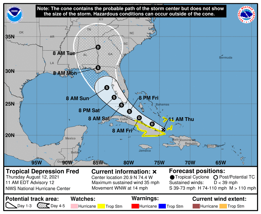
KEY MESSAGES:
1. Heavy rainfall today could lead to flash, urban, and small stream flooding, along with possible rapid river rises and the potential for mudslides in the Dominican Republic and Haiti.
2. Tropical storm conditions are possible in the southeastern Bahamas and portions of Cuba today.
3. Beginning Friday, heavy rainfall could lead to areal, urban, and small stream flooding, along with possible rapid river rises across southern Florida. Heavy rainfall associated with Fred will impact the remainder of Florida and parts of the Southeast this weekend and into next week.
4. There is a risk of tropical storm conditions beginning early Saturday in the Florida Keys and south Florida. This risk will spread northward along portions of the Florida west coast and to the Florida Panhandle through Monday. A Tropical Storm Watch will likely be issued for portions of the Florida Keys and the southern Florida Peninsula this afternoon.


