

Are you tired of seeing the empty old theater just standing there and nothing new to replace it?

The City of Miami Springs has a new proposal to provide a small incentive for property owners to redevelop and beautify this area.
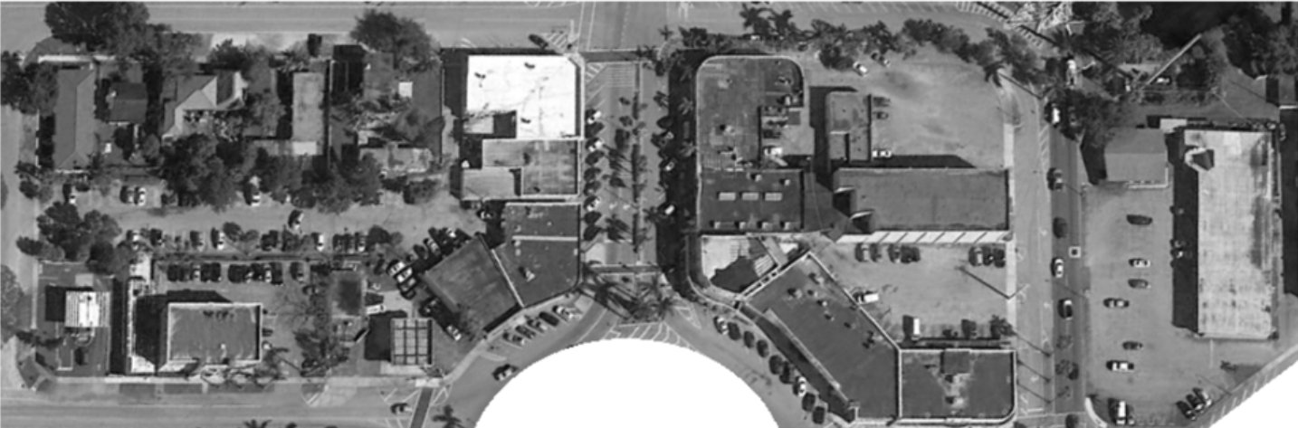
Step 1 is establishing a new Gateway District as depicted in the map below. (The city is NOT installing a new Gateway Sign or Entrance.) The proposed district is basically a rectangle that includes the Hook Square Shopping Center, the old Circle Theater, Ray’s Tae Kwon Do, Burritoville, the Starbucks shopping area, all the way to the Farm Stores.


Step 2 is providing the incentive and requirements to beautify the area. The plan allows an increase in the floor area ratio or FAR from 1.0 to 1.7, but only if the property owner augments and fulfills a set of creative standards detailed further below. A partial list of standards includes:
- Elements of the Pueblo/Mission Revival architectural
design standard. - Art in Public Places
- Community Entry Features
- Lighting
- Landscaping
- And more…(See full details below.)
The plan continues to allow for residential development on upper floors above retail, office and related uses. See the complete language of both ordinances below.
NOTE: The first reading will be held on Monday, June 11th at 7pm at City Hall during the next Council Meeting. Any resident who wishes to speak about the ordinances may sign up to speak before the meeting begins.
————
AN ORDINANCE OF THE CITY OF MIAMI SPRINGS, FLORIDA, APPROVING AN AMENDMENT TO THE TEXT OF THE CITY OF MIAMI SPRINGS COMPREHENSIVE
PLAN FUTURE LAND USE ELEMENT FOR A PORTION OF THE CENTRAL BUSINESS DISTRICT BY CREATING THE MIAMI SPRINGS GATEWAY OVERLAY DISTRICT;
PROVIDING FOR ENHANCED BUILDING REQUIREMENTS; APPROVING A SMALL SCALE AMENDMENT TO THE CITY’S FUTURE LAND USE MAP IN FURTHERANCE HEREOF; PROVIDING FOR IMPLEMENTATION; PROVIDING OF INCORPORATION INTO THE COMPREHENSIVE PLAN; PROVIDING FOR SEVERABILITY; PROVIDING FOR CONFLICTS; AND PROVIDING FOR AN EFFECTIVE DATE
WHEREAS, for many years, various aspects of a principal entrance into the City
of Miami Springs (the “City”)—the gateway to and from the City of Hialeah—have not
met community standards; and
WHEREAS, enhanced buildings, landscaping, signage, architecture and other
design standards and building regulations have been and continue to be needed to
ensure an attractive and viable physical environment to retain and attract economic
development and avoid unintended consequences resulting from current regulations;
and
WHEREAS, Goal 1 of the Future Land Use Element of the City’s Comprehensive
Plan calls for the City to offer the best residential environment consistent with the City’s
location and development history; and
WHEREAS, Objective 1.1 of the Future Land Use Element of the Comp. Plan
calls for the City to “maintain existing development and achieve new development and
redevelopment consistent with the community character articulated in [Goal 1] . . . .”;
and
WHEREAS, to achieve the foregoing goal and objective, the City has proposed
the creation of an overlay district, called the “Miami Springs Gateway Overlay District”
(the “Gateway Overlay District”), which establishes an area within the Central Business
District (“CBD”) land use category, that calls for enhanced buildings, landscaping,
signage, architecture and other design standards and building regulations; and
WHEREAS, the Gateway Overlay District supports and furthers the Comp. Plan’s
CBD policies by continuing to foster a suburban downtown that satisfies the retail,
personal, and professional services needs of the community, as well as advance
specialty shopping/restaurant/entertainment for the community; and
WHEREAS, a copy of the City’s Comp. Plan is attached hereto as Exhibit “A”;
and
WHEREAS, pursuant to Sections 163.3184 and 163.318, Florida Statutes, the
City is creating the Gateway Overlay District by way of a simultaneous amendment to
the City’s Comp. Plan and Future Land Use Map; and
WHEREAS, this Ordinance has received a recommendation from the City’s local
planning agency, has been properly read and advertised as provided by Florida law and
the required meetings and hearings have been conducted on its adoption; and
WHEREAS, the City Council hereby finds that the adoption of this Ordinance is
in the best interest of the City.
NOW, THEREFORE, BE IT ORDAINED BY THE MAYOR AND CITY COUNCIL
OF THE CITY OF MIAMI SPRINGS, FLORIDA, AS FOLLOWS: 1
Section 1. Recitals. The above-stated recitals are hereby confirmed, adopted
and incorporated herein and made a part hereof by this reference.
Section 2. Text Amendment. The Comprehensive Plan For the City of Miami
Springs is hereby amended as follows:
FUTURE LAND USE ELEMENT
GOAL 1: ACHIEVE THE FOLLOWING COMMUNITY CHARACTER:
* * *
Objective 1.1 Future Land Use Categories
* * *
Policy 1.1.8
The Future Land Use Category Descriptions:
* * *
Central Business District Category: This category of land use is intended to
foster a suburban downtown which will: 1) satisfy the frequent retail, personal
and professional service needs and desires of persons residing and/or working in
Miami Springs and surrounding areas making up its market area; and 2) provide
a specialty shopping/restaurant/entertainment destination for a large market
area. This category may allow a wide range of convenience and comparison
shopping facilities, restaurants, theaters and other compatible uses. Other uses
permitted on land within this category could include business and professional
office uses; residential uses on upper floors above retail, office and related uses;
public parks; municipal buildings and facilities; and public utilities necessary to
serve the uses within this category. Buildings within this category shall be limited
to a floor area ratio of 1.0.
Miami Springs Gateway Overlay District: This category of land use is an overlay
on, or a subarea of, the Central Business District. It is located within the Central
Business District for the area abutting and/or adjacent to the outgoing/incoming
vehicular bridges to/from the City of Hialeah, as identified in the City’s Future
Land Use Map. This overlay district intended to facilitate improved placemaking
by enhancing neighborhood character and authenticity of a principal entrance of
the City through participatory design and identifying projects such architecturally
significant buildings, entrance features, art in public places, improved
landscaping and signage, traffic calming features, and promotion of the City’s
history It is further intended that this overlay district will further the goals,
objectives, and policies of the Central Business District—to foster a suburban
downtown that satisfy the business, service, dining, and entertainment needs of
the community’s residents and business patrons. The buildings in this area shall
be limited to a floor area ration of 1.0, unless augmented by fulfillment of creative
excellence standards which may be implemented to permit a maximum floor area
ratio of 1.7. The uses for this overlay category are the same as those provided in
the Central Business District.
* * *
Section 3. Amendment to Future Land-Use Map. The City of Miami Springs
Future Land Use Map is hereby amended to create the “Miami Springs Gateway
Overlay District” for the area in the Central Business District bounded by Canal Street,
the alley southeast of Hook Square, South Royal Poinciana Boulevard, North Royal
Poinciana Boulevard and Nahkoda Drive, totaling ± 4.71 acres, as depicted in Exhibit
“B”, which is incorporated herein and made a part of the hereof by this reference. The
City Manager, by and through the Planning and Zoning Director, is authorized to make
the necessary changes as required to the Future Land Use Map to reflect the foregoing
change.
Section 4. Implementation. The City Manager and City Attorney are hereby
otherwise authorized and directed to implement the provisions of this Ordinance and to
take any and all necessary administrative actions as may be appropriate by their
position to execute the purpose of this Ordinance.
Section 5. Incorporation. The provisions of this Ordinance, to the extent
appropriate, shall become and be made a part of the Comprehensive Development
Ordinance No. -2018
Page 5 of 6
Master Plan of the City of Miami Springs. The City Clerk is authorized to take all actions
necessary to incorporate the provisions of this Ordinance into the Code of Ordinances,
including, but not limited to, renumbering or relettering sections and to change and that
the word “ordinance” may be changes to “section,” “article,” or such other appropriate
word or phrase in order to accomplish such intention.
Section 6. Severability. The provisions of this Ordinance are declared to be
severable and if any section, sentence, clause or phrase of this Ordinance shall for any
reason be held to be invalid or unconstitutional, such decision shall not affect the validity
of the remaining sections, sentences, clauses, and phrases of this Ordinance but they
shall remain in effect, it being the legislative intent that this Ordinance shall stand
notwithstanding the invalidity of any part.
Section 7. Conflicts. All ordinances or parts of ordinances, resolution or parts
of resolutions, in conflict herewith, are repealed to the extent of such conflict.
Section 8. Effective Date. This Ordinance shall become effective
immediately upon adoption.
ORDINANCE NO. ____ – 2018
AN ORDINANCE OF THE CITY OF MIAMI SPRINGS,
FLORIDA, AMENDING CHAPTER 150 OF THE CITY’S
CODE OF ORDINANCES BY CREATING SECTION
150.070.1, “MIAMI SPRINGS OVERLAY GATEWAY
DISTRICT”; PROVIDING FOR REGULATIONS
CONSISTENT WITH THE CITY OF MIAMI SPRINGS
COMPREHENSIVE PLAN; PROVIDING FOR
IMPLEMENTATION; PROVIDING OF INCORPORATION
INTO THE CODE; PROVIDING FOR SEVERABILITY;
PROVIDING FOR CONFLICTS; AND PROVIDING FOR AN
EFFECTIVE DATE
WHEREAS, for many years, various aspects of a principal entrance into the City
of Miami Springs (the “City”)—the gateway to and from the City of Hialeah—have not
met community standards; and
WHEREAS, enhanced buildings, landscaping, signage, architecture and other
design standards and building regulations have been and continue to be needed to
ensure an attractive and viable physical environment to retain and attract economic
development and avoid unintended consequences resulting from current regulations;
and
WHEREAS, pursuant to Chapter 163, Florida Statutes, the City has amended its
Comprehensive Plan and Future Land Use Map to create of an overlay district, called
the “Miami Springs Gateway Overlay District” (the “Gateway District”) which establishes
an area within the Central Business District (“CBD”) land use category, that calls for
enhanced buildings, landscaping, signage, architecture and other design standards and
building regulations, in furtherance of achieving the aforementioned goals; and
Ordinance No. -2018
Page 2 of 10
WHEREAS, to effectuate the goals and implement the policies of the City’s
Comprehensive Plan associated with the Gateway District, zoning regulations are
required; and
WHEREAS, the City Council hereby finds that the adoption of this Ordinance is
in the best interest and welfare of the residents of the City.
NOW, THEREFORE, BE IT ORDAINED BY THE CITY COUNCIL OF THE CITY
OF MIAMI SPRINGS, FLORIDA, AS FOLLOWS: 1
Section 1. Recitals. The above-stated recitals are hereby confirmed, adopted
and incorporated herein and made a part hereof by this reference.
Section 2. Amending Chapter 150 of the City Code. The Code of
Ordinances of the City of Miami Springs, Florida, is hereby amended by as follows:
CHAPTER 150 – ZONING CODE
* * *
ARTICLE VII. BUSINESS DISTRICT
* * *
Sec. 150-070.1. – Miami Springs Gateway Overlay District
(A) Purpose. The purpose of the Miami Springs Gateway Overlay District
(“Gateway District”), located within the Central Business District for the
area abutting and/or adjacent to the outgoing/incoming vehicular bridges
to/from the City of Hialeah, as identified in the City’s Future Land Use Map
and herein, is to facilitate placemaking by enhancing neighborhood
character and authenticity through participatory design and identifying
projects such architecturally significant buildings, entrance features, art in
public places, improved landscaping and signage, traffic calming features,
and promotion of the City’s history. The foregoing will further the goals,
objectives, and policies of the Central Business District, which are to foster
a suburban downtown that satisfy the business, service, dining, and
1 Coding: Strikethrough words are deletions to the existing words. Underlined words are additions to the existing words. Changes
between first and second reading are indicted with double strikethrough and double underline.
Ordinance No. -2018
Page 3 of 10
entertainment needs of the community’s residents, as further detailed in
the City’s Comprehensive Plan and Section 150.070 of the City Code.
(B) Boundary. As identified in the City’s Future Land Use Map, the Gateway
District shall be defined as that area bounded by Canal Street, the alley
southeast of Hook Square, South Royal Poinciana Boulevard, North Royal
Poinciana Boulevard and Nahkoda Drive. More specifically this area
includes: Lots 24-26 Block 86; Tract A, Block 85; Tract B, Block 85; Tract
C, Block 85; Lot 9, Block 85; Lots 1-2, Block 66; Lot 6, Block 66; Lot 7,
Block 66; Lot 8, Block 66 and Track G; Lots 10, 12-14 And Tracks E and
F; Lot 16, Block 66; Track D, Block 66; Lots 21-22, Block 66; Lots 31-34,
Block 66; Lots 28-30, Block 66; Lot 27, Block 66; Tract C, Block 66; and
Lots 21-22, Block 66. For reference, the area is identified below.
(C) Design Standards. The City desires for new and existing buildings within
the Gateway District to become more aesthetically pleasing, have
architectural elements that highlight the City’s history, facilitate pedestrian
activity and walkability, and assist in traffic calming. As opposed to a
mandate, the City desires to accomplish these objectives through
incentives in development standards that will encourage property owners
to improve their respective properties in a manner that results in cohesive
building design and features throughout the Gateway District. The
standards are as follows:
1. Building height limitations. In keeping with the applicable
requirement of the CBD, the maximum building height shall be no
more than forty (40) feet and no more than three (3) stories.
Rooftops may be activated provided that no vertical construction
exceeds the height restrictions stated herein.
Ordinance No. -2018
Page 4 of 10
2. Setbacks. The setbacks in the CBD shall remain in effect for the
Gateway District, except as follows:
a. All buildings shall be built to the front property line, but the
first floor shall be recessed ___ feet, so as to facilitate
expanded sidewalks or arcade for increased pedestrian
activity; and
b. No rear yard setback is required.
3. Uses. The uses in the CBD shall remain in effect for the Gateway
District, except that hotels shall be prohibited in the Gateway District.
Additionally, first floor uses along road rights of way shall be limited to
retail. Direct access to such uses and full storefront windows are
encouraged.
4. Architectural design. It is required that all new site development,
structures, buildings, remodelings and renovations show proper
architectural design concepts and be appropriate to their
surroundings. All new construction and remodeling and renovation
of existing buildings and structures within the Gateway District
shall:
a. exhibit elements of the Pueblo/Mission Revival architectural
design standard. Examples of these styles will be available
through the Office of the City Planner;
b. be designed in such a manner as to create, improve, or
connect pedestrian amenities in the subject property and
surrounding area, giving specific consideration to such
things as, without limitation, linkages in/between/among
circulation patterns, relationships to architectural and urban
design features, relationships to public and private spaces,
and accessibility, usability and coordination with adjacent
properties;
c. to the extent possible, install awnings or eyebrows for
portions of the project that abut City sidewalks;
d. be installed underground all on-site utilities. Large
transformers shall be placed on the ground within pad
amounts, enclosures or vaults;
Ordinance No. -2018
Page 5 of 10
e. provide adequate landscaping to screen all aboveground
facilities.
5. Floor Area Limitations. All buildings within the Gateway District
shall be limited to a floor area ratio (F.A.R.) of 1.0, in keeping with
the limitation of the CBD, except that properties may be
developed/redeveloped up to an F.A.R. of 1.7 through the
satisfaction of the creative excellence standards established in this
section.
6. Creative Excellence Standards. For a property to take advantage
of a project F.A.R. in excess of 1.0 as referenced in subsection 3
herein, a development or redevelopment project must incorporate a
combination elements from the Creative Excellence categories
provided below, which shall be demonstrated by the property owner
at the time of initial site plan review. Notwithstanding the cumulative
value of the Creative Excellence elements, no project may exceed
an F.A.R. of 1.7. No single element may be counted towards the
satisfaction of more than one standard. The schedule of Creative
Excellence elements for projects in the Gateway District are as
follows:
Category Creative Excellence Element
Amount of F.A.R.
(up to specified
amount
depending on
degree of
compliance)
A. Site Planning and
Design
a. Art in public places—Durable creations that can be
original works of art design specifically for the site
including, but not be limited to, sculptures, murals,
monuments, frescoes, fountains, paintings, stained
glass, or ceramics and may include architectural
designs, components or structures. The “art work”
medium can include, but not be limited to, glass,
steel, bronze, wood, stone and concrete. For
purposes of the art program, “art work” does not
include the following: (1) directional elements, such
as signage or graphics; (2) objects that are massproduced
in a standard design; or (3) landscape
0.2
Ordinance No. -2018
Page 6 of 10
gardening, unless substantially comprising durable
elements defined as “art work” under this section.
The art shall be place in an exterior area on the
property subject to the development or on public
property within the Gateway District, which is easily
accessible or clearly visible to the general public
from adjacent public property such as a street or
other public thoroughfare or sidewalk. At a minimum,
the art work shall cost one percent of total construction
cost as indicated on the Building Permit or $25,000.00
whichever is greater. The design and placement of the
art in subject to approval by the City during site plan
review. This element may be satisfied with a decorative
water features—Considering movement, sound,
reflection, recreation, cooling effect, architectural effect,
coordination with plaza or other special place, publicprivate
transition, visual impact, and relation to overall
project design. In the alternative, a property may elect to
pay the City an amount equal to the value of the art that
meets this element in lieu of art on the property, which
the City shall use for public art and beautification
improvements.
b. Community Entry Feature—A thematic architectural or
landscape design elements that incorporate a special
landmark feature or public art to identify the community,
representative of the City character. The Feature shall be
subject to approval by the City.
0.20
c. Directional Signage—A thematic, permanent sign
incorporated into a right of way feature that orients
pedestrians and drivers to facilities and other points of
interest. The design of the signage will be subject to
approval by the City.
0.20
C. Improvements:
Rights-of-Way
and On-Site
Public Spaces
a. Alley improvements—Resurfacing and lighting in
accordance with the specifications as established by
the City Engineer. Includes the placement of all utility
lines, transformers and related equipment underground
and/or in vaults
0.2
b. Right of Way improvements – improvements to
crosswalks, sidewalks, canal banks, curbing,
landscaping islands and other
0.2
c. Installation of trolley stops/bus shelter on the subject
property or neighboring property 0.15
Ordinance No. -2018
Page 7 of 10
D. Site
Improvements
a. Lighting—Installation of decorative lighting (any
combination building, landscape and site lighting) 0.1
c. Landscape maturity—This bonus applies to landscaping
that is a minimum 50% bigger than minimum standards
for onsite plantings.
0.2
d. Street trees, grates and irrigation—Landscaping on the
public right-of-way shall occur for the entire street
frontage of the property and shade trees shall be
planted no further apart than 30 feet on center. Palms
shall not be counted towards this elements.
0.1
(D) Parking Requirements. The CBD parking requirements as provided in
Section 150.070(E)(1-3) shall apply to the Gateway District, including,
without limitation, the grandfathering of provided parking, if any, for
existing buildings and current uses. Additionally, because of the
uniqueness of the buildings, configuration of parcels, and road network in
the Gateway District, the minimum parking space requirements and
design for new construction or alterations to existing structures that
expand occupiable space, shall be determined on a case-by-case basis.
The City Planner shall have the authority to establish parking
requirements for alterations and new construction by counting a
combination on-site and on-street parking and other elements identified
below. For any on-street parking space(s) counted towards the
satisfaction of a property’s requirement, or any spaces otherwise waived
as a result of one of the factors listed below, a fee shall be paid to the City
for each such parking space, in an amount set from time to time by
approved resolution of the City Council. The funds shall be used to fund
parking and wayfinding improvements in the Gateway District and the
CBD. In determining the parking requirements for non-grandfathered
properties, the following shall be considered:
1. availability of on-site parking;
2. availability of on-street parking;
3. provision of bicycle parking;
4. distance to, or inclusion of, bus and trolley stops;
5. internal capture of peak traffic trips as a result of mix of uses;
6. distance to public parking; and
7. walking accessibility of the site.
Ordinance No. -2018
Page 8 of 10
All on-site parking shall be appropriately landscape to provide visual relief
and, to the extent possible, shade.
* * *
Section 3. Implementation. The City Manager, City Clerk, and City Attorney
are hereby authorized and directed to implement the provisions of this Ordinance and to
take any and all necessary administrative actions as may be appropriate by their
position to execute the purpose of this Ordinance.
Section 4. Incorporation into the Code. The provisions of this Ordinance, to
the extent appropriate, shall become and be made a part of the Code of Ordinances of
the City of Miami Springs. The City Clerk is authorized to take all actions necessary to
incorporate the provisions of this Ordinance into the Code of Ordinances, including, but
not limited to, renumbering or relettering sections and to change and that the word
“ordinance” may be changes to “section,” “article,” or such other appropriate word or
phrase in order to accomplish such intention.
Section 5. Severability. The provisions of this Ordinance are declared to be
severable and if any section, sentence, clause or phrase of this Ordinance shall for any
reason be held to be invalid or unconstitutional, such decision shall not affect the validity
of the remaining sections, sentences, clauses, and phrases of this Ordinance but they
shall remain in effect, it being the legislative intent that this Ordinance shall stand
notwithstanding the invalidity of any part.
Section 6. Conflicts. All ordinances or parts of ordinances, resolution or parts
of resolutions, in conflict herewith, are repealed to the extent of such conflict.
Ordinance No. -2018
Page 9 of 10
Section 7. Effective Date. This Ordinance shall become effective
immediately upon adoption.


