It’s been a few years since we experienced the January 23rd, 2017 (EF-0 EF-1) tornado that ripped through Miami Springs. But today marks the 28 year anniversary of the February 2, 1998 “Ground Hog Day Tornado”…the EF-2 Tornado that struck Miami International Airport, Virginia Gardens, Miami Springs, and Hialeah.
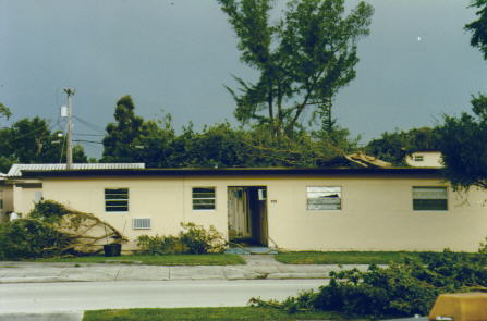
The storm started at Miami International Airport damaging some aircraft. It then cut through 36 Street in Virginia Gardens by the Pizza Hut damaging the roof of the Pizza Hut. It continued north and damaged some apartments in VG.
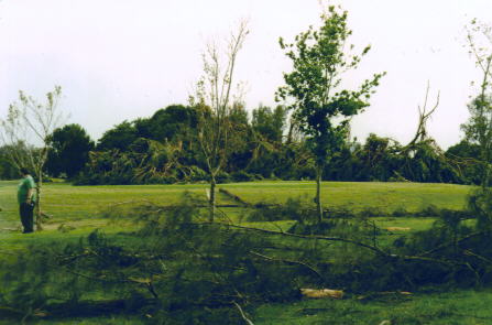
The tornado then cut through Curtiss Parkway and damaged some apartments between Curtiss Parkway and Eldron Drive. It then cut through the golf course and then through the Curtiss Parkway median destroying scores of trees. it hopped through Westward Drive and Canal Street before crossing to Hialeah near Tom Thumb. The storm cut from West Hialeah along 5th street and jumped between Palm Avenue and east 4th avenue before it hit the Hialeah Race Track property.
VIDEO COVERAGE OF TORNADO DAMAGE
RADAR IMAGERY
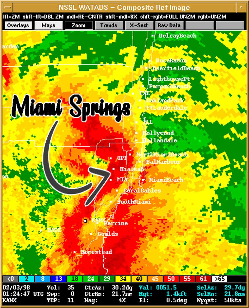
TORNADO CHRONOLOGY
Here’s the full chronology of the storm from the National Weather Service:
The tornado first touched down at 8:22 pm on the north edge of Miami International Airport near N.W. 36th Street and Curtis Parkway with F1-F2 intensity, damaging about a dozen planes. The NWS ASOS observation at Miami International Airport, located about 3/4 mile west of the touchdown point reported a wind gust of 104 mph (probably associated with the “rear flank downdraft”. The F2 tornado crossed through Virginia Gardens and south portion of Miami Springs in a 100-200 yard-wide path damaging many buildings and hurling a 2×4 inch board through an apartment door. The tornado showed F1 intensity across the remainder of Miami Springs, damaging roof tops and uprooting large trees. At 8:27 pm the tornado intensified to its maximum F2 intensity (125-150 mph), as it moved into southern Hialeah, severly damaging structures. The tornado weakened to F1 intensity near the Hialeah Racetrack. Just north of Hialeah Racetrack, the damage path widened to one to three miles, with indications of three or four individual tornados of F1 intensity moving in tandem toward the north. At 8:31 pm, the main tornado reintensified to F2 status as it approached Opa Locka Airport severely damaging the roof of the UPS facility then damaging or destroying 140 aircraft and a hanger at the airport blowing some debris nearly half a mile. The ASOS at Opa Locka Airport measured a gust of 67 mph. The tornados weakened slightly to F1 intensity as they moved through Carol City damaging houses and utility lines. At 8:34 pm they crossed the Dade-Broward county line and damaged a strip shopping center in Miramar. The multiple tornados moved across North Perry Airport at 8:36 pm where 40 aircraft were destroyed and another 40 were damaged. The tornados weakened to F0-F1 intensity as they continued toward the north northeast damaging a shopping center in Davie near Orange Road and Hiatus Road. The tornados were F0 intensity as they moved north damaging trees, signs and some roofs before lifting at 8:44 pm near Broward Boulevard just west of the Florida Turnpike in Plantation. The thunderstorm that produced the tornados continued to the northeast producing sporadic minor damage through northeast Broward county before exiting the coast into the Atlantic.
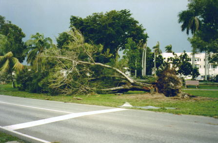
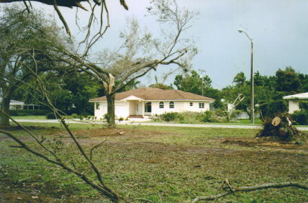
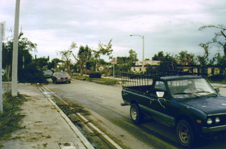
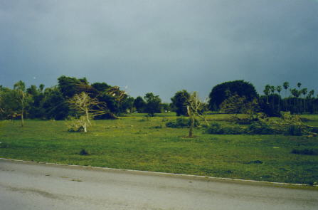
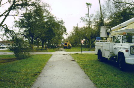
Below are some of the first digital pictures ever published on MiamiSprings.com. (Digital photography has come a long way since then.)
Photos of Tornado Damage in Miami Springs

Feb 2nd: on this date in 1998, the “Groundhog Day Tornado” ripped through SE Florida from @iflymia (where winds gusted to 104 mph), through Miami Springs, Hialeah, and Pembroke Pines, causing EF-2 damage. https://t.co/cZsJgwExut #flwx #weatherhistory #SoFla pic.twitter.com/3ypSlzq16D
— NWS Miami (@NWSMiami) February 2, 2019
Here`s the full report of the 1998 tornado that struck Miami Springs and Virginia Gardens provided by the National Weather Service:
Summary of Severe Weather Outbreak in South Florida: February 2, 1998
JAMES B. LUSHINE, Warning and Coordination Meteorologist
BRIEF METEOROLOGICAL SYNOPSIS
A low pressure center formed in the Gulf of Mexico on February 1, 1998 and eventually deepened to a minimum central pressure of 989 mb as it tracked across the northeast Gulf– a not unusual occurrence during a strong El Niño episode. In response to the deepening low, winds increased to gale force during mid-morning of February 2 over south Florida. A warm front moved northward from the Straits of Florida ushering in tropical air to the Keys and the southern peninsula by midday. An area of severe thunderstorms formed in the warm sector over the southeast Gulf of Mexico and moved into the lower Keys beginning around mid-afternoon Monday, February 2, 1998, and spreading to the southeast Florida coast by evening.
TORNADOES AND SEVERE THUNDERSTORMS
The area of severe thunderstorms produced four confirmed tornado paths in south Florida. The tornado path in Dade-Broward county was likely caused by four individual tornados occurring simultaneously along a portion of its path making a total of seven tornado touchdowns. A dozen or more other severe thunderstorms (wind gusts above 57 mph) occurred across the Keys, most of Dade and Broward counties and portions of Palm Beach and Glades counties. The highest wind measured during the event was 119 mph, a delayed report from the C-MAN instrument at Long Key in the middle Keys. The ASOS at the Miami International Airport measured a peak wind gust of 104 mph. Rainfall along the southeast Florida coast was locally heavy with widespread amounts of 3 to 6 inches.
CHRONOLOGY AND STATISTICS OF DADE-BROWARD TORNADO
The tornado first touched down at 8:22 pm on the north edge of Miami International Airport near N.W. 36th Street and Curtis Parkway with F1-F2 intensity, damaging about a dozen planes. The NWS ASOS observation at Miami International Airport, located about 3/4 mile west of the touchdown point reported a wind gust of 104 mph (probably associated with the “rear flank downdraft”. The F2 tornado crossed through Virginia Gardens and south portion of Miami Springs in a 100-200 yard-wide path damaging many buildings and hurling a 2×4 inch board through an apartment door. The tornado showed F1 intensity across the remainder of Miami Springs, damaging roof tops and uprooting large trees. At 8:27 pm the tornado intensified to its maximum F2 intensity (125-150 mph), as it moved into southern Hialeah, severly damaging structures. The tornado weakened to F1 intensity near the Hialeah Racetrack. Just north of Hialeah Racetrack, the damage path widened to one to three miles, with indications of three or four individual tornados of F1 intensity moving in tandem toward the north. At 8:31 pm, the main tornado reintensified to F2 status as it approached Opa Locka Airport severely damaging the roof of the UPS facility then damaging or destroying 140 aircraft and a hanger at the airport blowing some debris nearly half a mile. The ASOS at Opa Locka Airport measured a gust of 67 mph. The tornados weakened slightly to F1 intensity as they moved through Carol City damaging houses and utility lines. At 8:34 pm they crossed the Dade-Broward county line and damaged a strip shopping center in Miramar. The multiple tornados moved across North Perry Airport at 8:36 pm where 40 aircraft were destroyed and another 40 were damaged. The tornados weakened to F0-F1 intensity as they continued toward the north northeast damaging a shopping center in Davie near Orange Road and Hiatus Road. The tornados were F0 intensity as they moved north damaging trees, signs and some roofs before lifting at 8:44 pm near Broward Boulevard just west of the Florida Turnpike in Plantation. The thunderstorm that produced the tornados continued to the northeast producing sporadic minor damage through northeast Broward county before exiting the coast into the Atlantic.
Maximum Intensity: 125-150 mph (F2)
Time and Location of touchdown: 8:22 pm at north edge of Miami Intl Airport
Time and Location of lifting: 8:44 pm in Plantation (near Broward Blvd and 54th St)
Total path length: 21 miles
Average damage path width: 100-200 yards
Minimum damage path width: 10 yards
Maximum damage path width*: 1-3 miles
Average Direction/Speed of movement: North Northeast 50 mph
Time on ground: 22 minutes
*4 tornados occurring simultaneously across the path
CASUALTIES AND DAMAGE
In Dade and Broward counties the severe thunderstorms and tornados caused no fatalities but at least six injuries. A total of 235 aircraft were damaged or destroyed at Miami International, Opa Locka, and North Perry airports. Damage to structures in Dade county included 32 homes destroyed, 205 with major damage and 380 with minor damage. Hialeah Hospital, a flea market and a carnival suffered extensive damage. At least four vehicles were overturned. Dozens of utility poles along with hundreds of trees were snapped. In Dade and Broward counties around 600,000 people suffered power outages at some time, and 200 people were left homeless. Losses from the severe weather in south Florida are estimated between 120 and 148 million dollars, the greatest weather-related monetary loss ever, outside of a significant tropical cyclone or major freeze.
The loss total was calculated as follows:
Damage to public facilities: $19 Million
Insured losses: $25 Million
Uninsured losses: $25-50 Million
Agricultural losses: $39 Million
Marine losses: $12-15 Million
Total losses: $120-148 Million
In the Keys, damage to houses occurred particularly near Grassy Key, Islamorada and Conch Key and utility lines were down over many areas of the Keys. Losses to marine equipment, especially lobster traps, was heavy.
In Glades county a tornado damaged several mobile homes in Buckhead Ridge and severe thunderstorm winds caused damage in Moore Haven and Lakeport. Damage totals are estimated at $75-100 thousand.
Damage in Palm Beach, Collier and Hendry counties is considered minimal.
MARINE CONDITIONS
Due to the deepening low pressure in the Gulf of Mexico, winds approaching gale force preceded the onset of the severe thunderstorms/tornados. One person was killed in the lower Keys when crushed between two boats during these strong winds. Several rescues of boaters were made in the lower Keys. At least three large boats ran aground off the southeast Florida coast. There was minor beach erosion and tidal flooding along portions of the Atlantic and Gulf of Mexico coasts of south Florida and in the Keys.
SUMMARY OF CONFIRMED SOUTH FLORIDA TORNADOS
Location Time Max Intensity* Length Warning Lead Time
Grassy Key 1850-1852EST F1 1 mile 50 minutes
Islamorada 1910EST F0 Short 8 minutes
Dade-Broward 2022-2044EST F2 21 miles 48 min (Dade)
12 min (Broward)
Buckhead Ridge 2115EST F0 Short None
*Fujita Scale
F0 40-72 mph F1 73-112 mph F2 113-157 mph
HISTORICAL PERSPECTIVE
The tornados in Dade county on February 2, 1998 were the most intense since December 20, 1973 (during another major El Niño episode) when an F2 tornado tore a 6-mile long path through Homestead, injuring 9 and causing about $3 million (adjusted to 1998 values) in damage. The February 2, 1998 tornados caused losses estimated between 65 and 80 million dollars, the highest amount ever recorded in Dade county from a tornadic event, exceeding the approximately $15 million sustained in the tornado of June 17, 1959 (damage adjusted to 1998).
Two F3 intensity tornados have been recorded in Dade county– in 1959 and 1925. The 1959 tornado injured 77 people while the 1925 tornado on April 5 was the only killer tornado in Dade county history, killing five and injuring more than 35 (during a major La Niña episode).
SEVERE WIND GUSTS (greater than 57 mph)
Location Peak Wind Remarks
Long Key 119 mph Measured by C-MAN instrument
Miami International Airport 104 mph ASOS measurement 3/4 mile west
of initial tornado touchdown
Hollywood 104 mph Estimated by trained observer
Duck Key 97 mph Estimated from unofficial observer
Molasses Reef 84 mph Measured by C-MAN instrument
Long Key 72 mph Measured by C-MAN instrument
Fowey Rocks 71 mph Measured by C-MAN instrument
Sombrero Key 70 mph Measured by C-MAN instrument
10 miles south of Miami 70 mph Estimated by trained spotter
Key West International Airport 68 mph Measured
Opa Locka Airport 67 mph ASOS measurement
Homestead Air Reserve Base 66 mph Measured
Lake Worth Inlet 63 mph Measured by C-MAN instrument
Sand Key 61 mph Measured by C-MAN instrument
Pembroke Pines 60 mph Estimated by NWS employee
Fort Lauderdale 60 mph Estimated by sheriff`s office
Virginia Key 60 mph Measured by unofficial Observer
PRINCIPAL WARNINGS, WATCHES, ADVISORIES, STATEMENTS, FORECASTS
Type Location Time Issued Lead Time
Extended Public and Marine Forecasts S Florida 600 pm Thu Jan 29 96 hours
State Forecast Discussion S Florida 230 pm Fri Jan 30 72 hours
Hazardous Weather Outlook S Florida 515 am Sun Feb 1 36 hours
Special Weather Statement S Florida 330 pm Sun Feb 1 24 hours
Lake Wind Advisory S Florida 415 am Mon Feb 2 5 hours
Wind Advisory S Florida 929 am Mon Feb 2 1 hour
Gale Warning S Florida 1030 am Mon Feb 2 1/2 hour
Coastal Flood Watch S Florida 1031 am Mon Feb 2 0-6 hours
Flood Watch S Florida 123 pm Mon Feb 2 5-10 hours
Tornado Watch S Florida 131 pm Mon Feb 2 5-8 hours
Local Airport Advisory SE Florida 220 pm Mon Feb 2 6 hours
Tornado Warning Lower & Middle Keys 600 pm Mon Feb 2 50 minutes
Tornado Warning Middle & Upper Keys 702 pm Mon Feb 2 8 minutes
Tornado Warning E Dade 734 pm Mon Feb 2 48 minutes
Tornado Warning E Broward 829 pm Mon Feb 2 6 minutes
Urban Flood Advisory E Dade/E Broward 854 pm Mon Feb 2 Unknown
VERIFICATION OF ALL WARNINGS
Type of Warning Area Time Valid Verified by
(Tor/G[mph]) Lead Time
Special Marine Warning Florida Straits 2:15-4:20 pm G43 45 minutes
Tornado Warning and SMW Marquesas to Tortugas 3:32-5:30 pm None —-
Tornado Warning and SMW Lower Keys 3:51-5:50 pm G68 57 minutes
Severe Thunderstorm Warning Lower Keys 4:16-5:15 pm G68 22 minutes
Severe Thunderstorm Warning Collier & Mainland Monroe 4:54-6:25 pm None —-
Special Marine Warning Florida Straits
& Florida Bay 5:20-7:20 pm G82 5 minutes
Severe Thunderstorm Warning All Keys 5:27-7:00 pm G80 18 minutes
Tornado Warning Lwr & Middle Keys 6:00-7:05 pm Tornado 50 minutes
Severe Thunderstorm Warning Broward County 6:19-7:20 pm None —-
Severe Thunderstorm Warning Collier & Mainland
Monroe 6:25-8:00 pm Funnel Cloud 5 minutes
Severe Thunderstorm Warning Dade 6:39-7:40 pm G60 51 minutes
Severe Thunderstorm Warning All Keys 7:02-8:00 pm Tornado 8 minutes
Tornado Warning W Dade 7:18-8:10 pm G60 12 minutes
Tornado Warning All Keys 7:23-8:25 pm G119 37 minutes
Tornado Warning Dade 7:34-8:35 pm Tornado 48 minutes
Severe Thunderstorm Warning Broward 8:12-9:15 pm Tornado 32 minutes
Tornado Warning E Broward 8:29-9:30 pm Tornado 5 minutes
Severe Thunderstorm Warning Middle & Upper Keys 8:31-9:30 pm G79 29 minutes
Severe Thunderstorm Warning Palm Beach County 8:52-9:55 pm G63 53 minutes
Special Marine Warning Lake Okeechobee 9:15-10:20 pm G60 20 minutes
Special Marine Warning Florida Straits
& Florida Bay 9:30 pm-12:30 am G45 30 minutes
Special Marine Warning Jupiter Inlet to
Angelfish Key 9:38-11:40 pm G63 22 minutes
Tornado Warning N Palm Beach County 10:18-11:20 pm None —-
Total Warnings Issued: 24
Total Warnings Verified: 20
Average Lead Time: 28 minutes
RAINFALL
Location Amount(inches)
Westchester 6.40*
Hollywood 5.27
West Kendall 5.24*
Fort Lauderdale 5.15*
Miami Intl Airport 4.56
Homestead 4.50*
Miami 4.30*
West Miami 4.06
Coral Springs 3.90
Homestead General Aviation 3.88
North Dade 3.28
Fort Lauderdale 3.00
Key West 2.41
Tamiami Airport 2.03
Clewiston 1.51
West Palm Beach 1.30
Naples 0.90
*Unofficial observation
JAMES B. LUSHINE–Warning and Coordination Meteorologist
HISTORICAL TORNADOS IN MIAMI SPRINGS AREA:
- April 5, 1925
- (Hialeah to Miami)
- Possible F3 Category Tornado
- May 12, 1997
- Downtown Miami Tornado
- F1 Tornado
- February 2, 1998
- (Miami International Airport, Virginia Gardens, Miami Springs, Hialeah, Opa-Locka, Pembroke Pines)
- EF-2 Tornado
- January 23, 2017
- Miami Springs
- EF-0 Tornado
- January 27, 2019
- (Hialeah Tornado)
- EF-0 Tornado


