

The City of Miami Springs hired Bermello Ajamil (the firm that seems to get every Miami Springs contract) to conduct a flood vulnerability study for the City of Miami Springs.
100 Year Flood Map of Miami Springs
The map below produced by B&A shows what would happen theoretically if Miami Springs experienced a once in a hundred year flood in Miami Springs. As you can see in this report, most of Miami Springs is covered in green and yellow. The areas in white would experience no flooding. The areas in green could see anywhere between 0 to 1.5 feet of flooding. The areas in yellow would see anywhere from 1.5 feet to 3 feet of water.
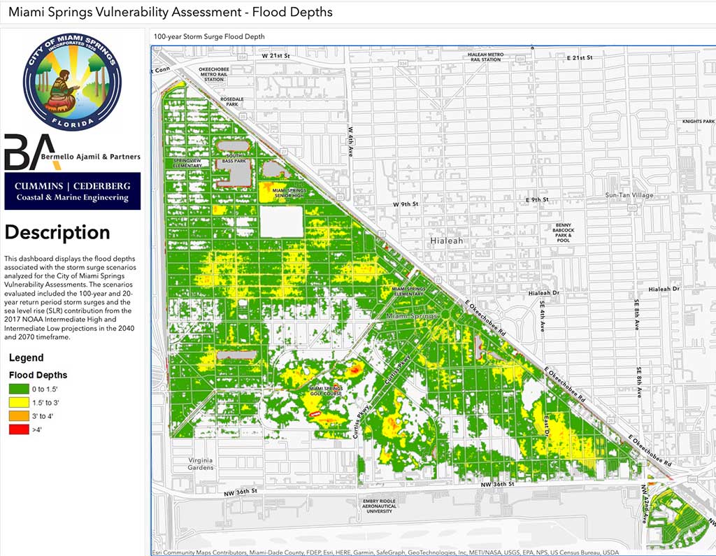
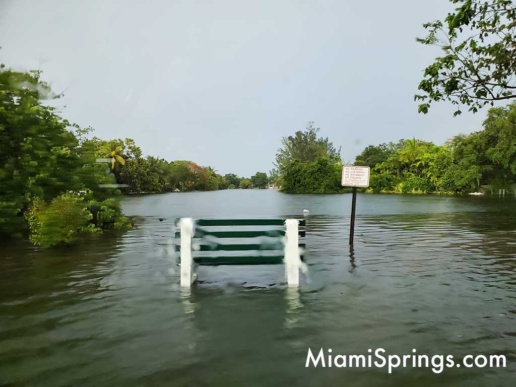
Using history as a guide, we don’t dispute the map shown above. Miami Springs has had some historical flooding over the last 100 years with flood depths that match the description above.


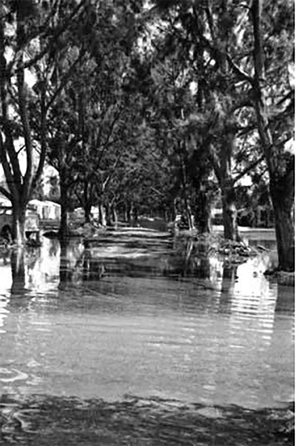
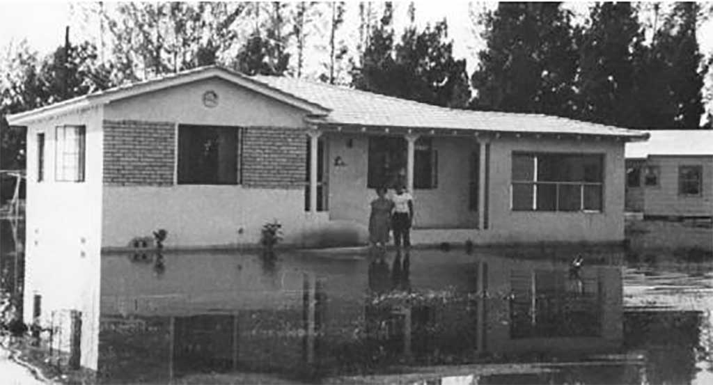
In 1947, the area was impacted by two storms. (Not dissimilar to 2005 when we got hit with Katrina and Wilma in the same year.). The first storm to hit the area was the 1947 Fort Lauderdale Hurricane that struck on September 16th. According to Wikipedia, “Half the homes in Miami Springs” were flooded by this storm.
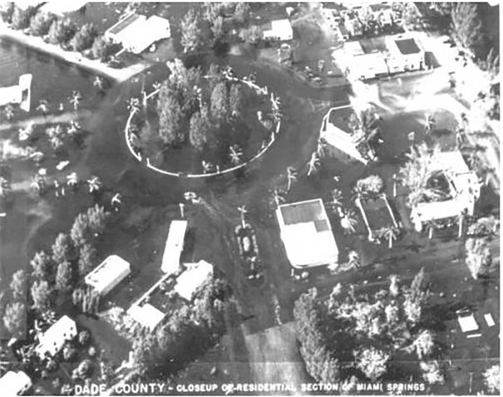
But that wasn’t the only storm to hit the area. Less than 30 days later, on October 12, 1947, Hurricane King dumped a record amount of rain in the area. According to Wikipedia, a “weather observation site in Hialeah” recorded over an inch of rain in just 10 minutes, and 6 inches of rain in just over one hour. The continuous rainfall and the previously saturated ground left Hialeah “submerged under 6 feet of water. Similarly, ‘waist deep’ depths were reported in nearby Miami Springs.”
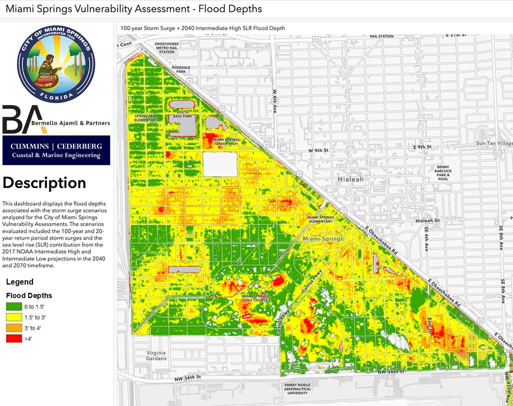
2040 Storm Surge Flood Map of Miami Springs with Low Sea Level Rise
The map below shows what a theoretical 100 year flood would look like by the year 2040. Why is the map below different from the map above? It considers a low amount of sea level rise. Now, to be clear, this map doesn’t mean Miami Springs will be under water in 2040. What this map shows is the possible flooding should we receive a 100 year flood from a torrential downpour (a la Fort Lauderdale’s recent flooding with 26 inches of rain in a day) or a 100 year storm surge from a Hurricane.
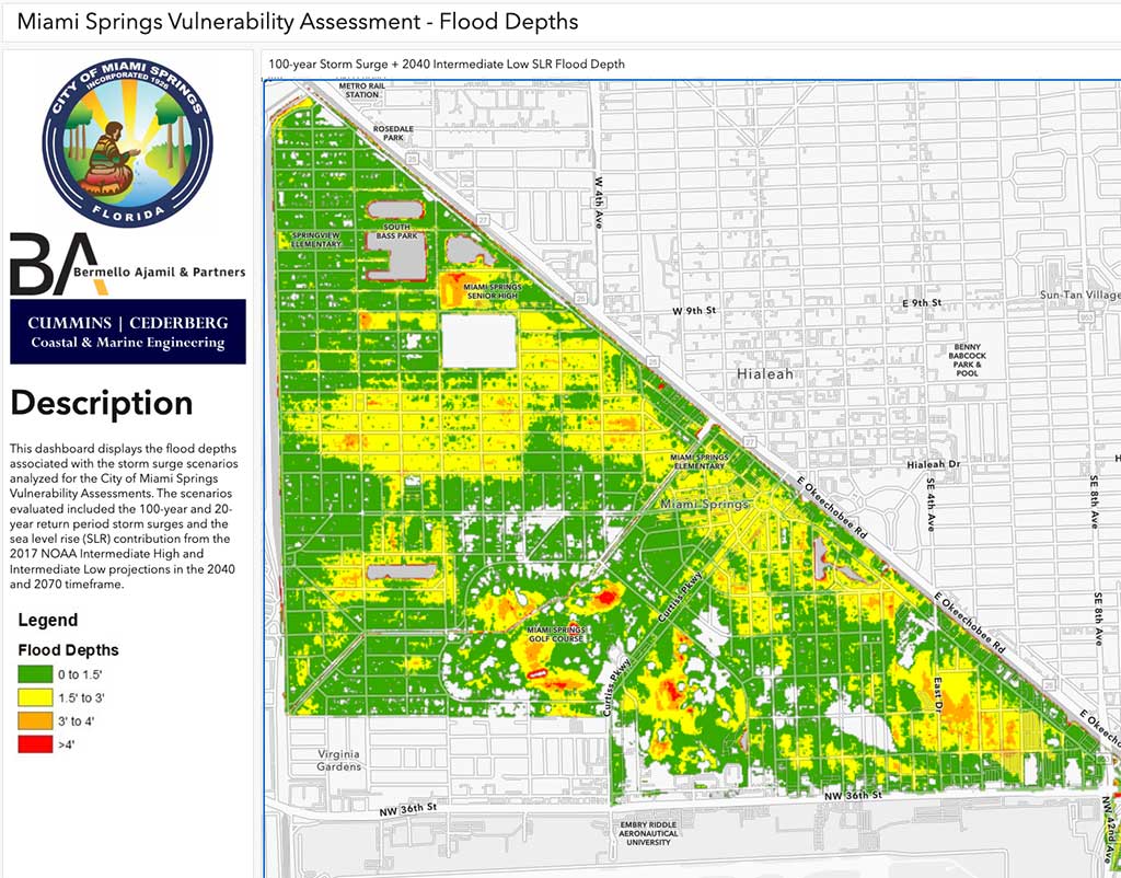
As you can see in the map above, there are several pockets of orange and red. The orange areas are projected to be flooded with 3 to 4 feet of water. The areas in red have 4 feet of water or more.
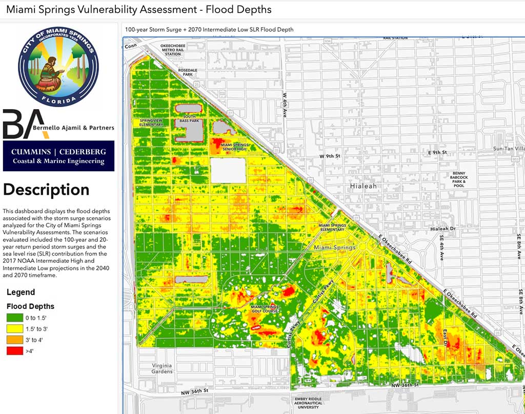
2070 Storm Surge Flood Map of Miami Springs with Low Sea Level Rise
The map below produced by B&A shows what would happen theoretically if Miami Springs experienced a once in a hundred year storm surge in 2070. This assumes a low forecast of sea level rise over the next 50 years. Again, this doesn’t mean Miami Springs will be underwater in 50 years. Miami Springs is expected to be dry in 50 years. However, this map estimated what a storm surge would look assuming a higher sea level by 2070.
What if Sea Levels Rise Faster?
Plain and simple. If the Atlantic Ocean and Biscayne Bay are higher, that means several things:
- The volume of water in Biscayne Bay is greater
- The water level of the Miami River rises
- The salt water pressure on the Biscayne Aquifer is greater
- Salt water intrusion (which currently reaches the eastern edge of town) will move further west
- The underground water table would rise as the salt water and the ground water find a new equilibrium
- As a result, Canal levels may rise due to the rise of the water table
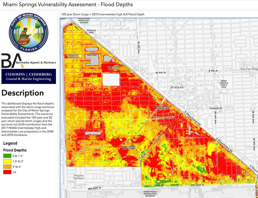
The following 2 maps show what Miami Springs would look like in 2040 and 2070 if we were to experience a 100 year storm surge and a high amount of sea level rise. Again, this doesn’t mean Miami Springs is under water with a high sea level rise. This is just what it might look like if there’s a high sea level rise AND we get a storm surge.
As you can see a storm surge in 2040 would have several areas in Miami Springs under 4 feet of water.
If sea levels rise at a higher forecast level, a storm surge in 2070 would bury much of Miami Springs with over 4 feet of water according to the B&A map shown below.
As we stated earlier, history has proven Miami Springs is susceptible to flooding that can reach waist deep levels. That was back in 1947. If it happened then, it can absolutely happen again.
Forget about climate change politics and the speed of sea level rise. The reality is that the right kind of storm can put Miami Springs under several feet of water right now. So we appreciate the City Council’s careful consideration of infrastructure improvements for drainage and flood mitigation.
That said…
Follow the Money
Call me the skeptical one, but I find it immensely humorous that the people tasked with creating the risk assessment (Bermello Ajamil) are the same people tasked with coming up with a solution and then probably building the solution. Does anyone else think that’s strange?
I’m going to quote Jose Lopez, the Director of Environmental Engineering at Bermello Ajamil, who gave a very professional presentation at Monday’s Miami Springs City Council Meeting:
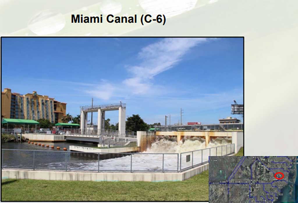
“This is very important because once we can identify that the [Miami] Canal is one of the critical assets with the City, that would qualify to apply for funding next year. And that’s the next step that we’re planning to do in July. We’re going to get funding to construct. And that’s why it’s very important this slide.“
Okay. Wait. What? Did he just say, “We’re going to get funding to construct.”
I’m sorry. Construct what? New water pumping stations? Elevated roads? A City Hall on stilts? We haven’t even seen a plan yet and he’s talking about funding to construct. You don’t even know how much money to ask for without a plan.
Obviously any construction would have to be approved by the City Council, but I found it amusing how Lopez said “We’re going to get funding to construct” before any plan has been laid out. Again, call me the skeptical one, but that kind of language leaves me thinking this contractor doesn’t care what they build as long as they get the money to build it.
Now, to be clear, I’m not opposed to infrastructure building and hardening. I just hope whatever plan comes out that it doesn’t automatically go to Bermello Ajamil. I hope it goes out to bid. Bermello Ajamil is not the only qualified contractor in all of Florida.
Possible Solutions
We’re definitely curious to see the kinds of solutions the team at Bermello Ajamil produce, but here are a few obvious solutions:
Canal Maintenance:
Canal maintenance is boring because it’s not flashy or trendy, but it does work. During a flooding event, the main goal is to move water out. And canals have the capacity to hold water and move it out. Miami Springs has several canals including the Ludlam Canal, the Melrose Canal, the Esplanade Drive Canal, and of course, the Miami Canal. In order for water to flow freely through those canals, they must be maintained. That means overgrown vegetation must be removed. That means hardening the canal banks as we see along Esplanade Drive. It’s not sexy, but it is critical.
Better Drainage:
We have known areas of flooding today. We know what the risks are if we get a once in a hundred year storm. The project doesn’t have to be completed all at once, but the city can start adding drainage to known low lying areas as well as areas that may not flood today, but are projected to flood under storm surge.
Localized Pump Stations:
Getting the canals working smoothly does nothing if we can’t get the water from flooded areas to the canals. In prior floods, we’ve seen hoses running down Hammond Drive to pump out water level from the overflown lake to the Melrose Canal. Does the city need to invest in underground piping and pumping that could move water out from flooded canals and low lying areas to our canals?
Can Miami Springs Experience Storm Surge?
We’ve covered this in the past. Despite Miami Springs being several miles inland, we are still susceptible to a Hurricane’s storm surge. We’re not talking about climate change or sea level rise or any of that.
We’re talking about the entire northeastern border of the City of Miami Springs is adjacent to the Miami Canal. That canal connects to the Miami River. The Miami River connects directly to Biscayne Bay. And Biscayne Bay connects to the Atlantic.
In other words, if we get a strong enough storm with an eye that enters around Brickell or just south of Brickell, and enters in a northwesterly direction, the winds would push the storm surge up the Miami River flooding everything along the Miami River basin including the City of Miami Springs.
Evacuation Zone D
You may not realize this but Miami Springs residents live in an evacuation zone. It’s called Evacuation Zone D. You can see it in the map below.

Again, this has to be a strong storm that takes a very specific path. You need a strong storm surge and the surge has to be pushed up river.
That being said, it’s hard to imagine a 12 to 18 foot storm surge this far inland. However, as you can see below, prior hurricanes have flooded the Miami Springs area with 3 – 4 feet of water.
For this to occur today, you’re talking about a catastrophic storm surge that bypasses all flood control systems and overwhelms the Miami River and Miami Canal and floods everything near the river…including Miami Springs and South Hialeah.
Fortunately, for this to happen, a hurricane needs to come in a very specific direction to push the storm surge up the river, making it an unlikely, but not impossible scenario.
As we have learned, each storm is different. Some are minor inconveniences, while other storms can be life threatening and devastate the area.
Miami Springs hasn’t had a major flood since the October Flood of 1991. Many improvements have been made to the drainage systems in the area to prevent similar flooding. But no drainage system can move water out when the entire area is overwhelmed by deluge and storm surge. Especially if the Miami River and Miami Canal are themselves overwhelmed.
Hopefully, we never have to experience a storm surge up the Miami River, but if you hear an order to Evacuate Zone D, heed the warning and leave Miami Springs for higher ground away from water.


