

Temperatures will be dropping significantly this weekend. Miami Springs / Virginia Gardens is forecast to reach a low temperature of 38 degrees Saturday night / Sunday morning. However, the wind chill will make it feel much colder. As a result, the Miami office of the National Weather Service has issued the following special weather statement:
…FREEZING TEMPERATURES POSSIBLE ACROSS PARTS OF SOUTH FLORIDA THIS WEEKEND…
A strong cold front is forecast to move down the Florida peninsula Friday night, and move off the southeast Florida coast during the pre-dawn hours of Saturday. Following the passage of the front, much colder air driven by gusty northwest winds will push into South Florida and usher in the coldest temperatures of the season so far.

The source region of the air mass following the front is from northern Canada, and only limited modification of this air mass is expected as it moves directly southward from the northern Plains into Florida this weekend. As a result, temperatures on Saturday are forecast to not get out of the 50s over most of the area, and even southern areas around Miami may struggle to reach 60 degrees under clearing skies and gusty northwest winds.
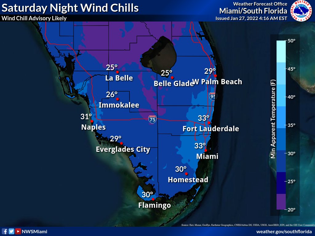
This will set the stage for the coldest night and morning which will likely be Saturday night and Sunday morning. Confidence continue to increase for freezing temperatures early Sunday morning over inland Southwest Florida, primarily Glades, Hendry, inland Collier, and Western Palm Beach County. In these areas, duration of temperatures of 32 degrees or below could be as much as 4 hours. Over the rest of the area, low temperatures Sunday morning are forecast to range from the mid 30s over the outlying suburbs of the east and west coasts, upper 30s Gulf coast, and upper 30s to lower 40s over most of metro Southeast Florida.
Northwest winds will stay in the 5 to 10 mph range Saturday night and Sunday morning, and as high as 15 mph near the coasts. This will cause lowest wind chill readings early Sunday to be in the 20s over most of the interior areas, and near 30 to the lower 30s elsewhere.
Another cold night is expected Sunday night and Monday morning, and although it may not be as cold as Sunday morning, freezing temperatures and frost are possible over many interior areas.
Stay informed on the latest forecasts on the upcoming cold snap.


